
Search Results

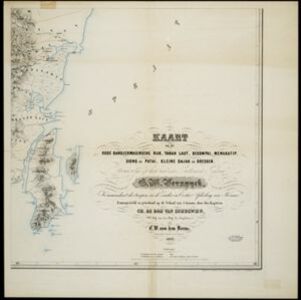
Kaart van het oude Bandjermasinsche rijk, Tanah Laut, Bekompai, Mengkatip, Siong en Patai, Kleine Dajak en Doesoen
1862
Indonesia
A map of the south-eastern tip of Borneo (modern South Kalimantan) spread over four sheets, featuring mountains, wetlands and rivers. Created by the Dutch colonial authorities, small flags mark fortifications of Dutch and auxiliary troops.
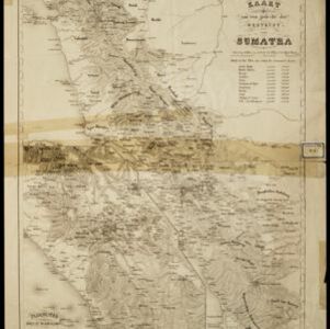
Kaart van een gedeelte der Westkust van Sumatra
1855
Indonesia
Hachures—short lines/dashes that give a sense of the shape and steepness of terrain—are used to show the mountains of Sumatra’s west coast, and of the Padang Highlands and Lowlands. Text lists the heights of some of the region’s chief mountains.

Kaart van het eiland Java uit de nieuwste bronnen zamengesteld
1855
Indonesia
Map of Java divided into administrative areas (‘residencies’ and ‘regencies’). Mountains are represented by hachures, short lines/dashes that give a sense of the shape and steepness of terrain. Postal routes and roads are also marked.

The continent and islands of Asia: with all the latest discoveries
1839
Brunei, Cambodia, East Timor, Indonesia, Laos, Malaysia, Myanmar, Papua New Guinea, Singapore, Philippines, Southeast Asia, Thailand, Vietnam
On this map of Asia, the South China Sea is labelled ‘Malayan Sea’. Small islands, shoals and reefs are shown. A label in Cochin China (Vietnam) reads ‘mountains inhabited by the uncivilized people called Kemoys’.
- [remove]Cartouche7
- Legend4
- Illustration3
- Elevation1
- Inset Map1
- [remove]Contour Lines/Elevation7
- Longitude and Latitude7
- Scale6
- Written Note/Details4
- Compass Rose1


