
Search Results
Filter
Map Attributes
Contour Lines/Elevation
Remove constraint Map Attributes: Contour Lines/Elevation
Insets
Inset Map
Remove constraint Insets: Inset Map
Detailed Location
Dutch East Indies
Remove constraint Detailed Location: Dutch East Indies
Printer/Publisher
Carl Wilhelm Mieling
Remove constraint Printer/Publisher: Carl Wilhelm Mieling
3 Results found


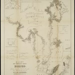
Kaart der verkennings reizen op Borneo
1853
Indonesia
Map charting expeditions in southern and eastern Borneo by the German geologist Carl Schwaner in the 1840s. Includes an inset map of rivers and watersheds in central Borneo, nine cross sections of the heights of rivers, and a plan of a gold mine.
- Filter from 1853 to 1855
- [remove]Dutch East Indies3
- Java2
- Straat Sunda2
- Sunda Strait2
- Barito River1
- Batang Barito of Banjer Rivier1
- Batang Moeroeng1
- Borneo1
- [remove]Contour Lines/Elevation3
- Scale3
- Longitude and Latitude2
- Written Note/Details2
- [remove]Carl Wilhelm Mieling3
- A.J. Bogaerts2
- Ministerie van Kolonien2


