
Search Results
Filter
Map Attributes
Contour Lines/Elevation
Remove constraint Map Attributes: Contour Lines/Elevation
Land Features
Jungle/Wooded Area
Remove constraint Land Features: Jungle/Wooded Area
Collections
National Library Board Singapore
Remove constraint Collections: National Library Board Singapore
3 Results found


Malay Archipelago, or East India Islands
1851
Brunei, Cambodia, East Timor, Indonesia, Laos, Malaysia, Myanmar, Papua New Guinea, Philippines, Singapore, Southeast Asia, Thailand, Vietnam
This mid-19th century map of Southeast Asia is illustrated with drawings of indigenous people from New Guinea, a ‘bee bear’ (probably a sun bear), a sailboat in front of Victoria Mount in New Guinea, and a village and palm trees in Sarawak, Borneo.
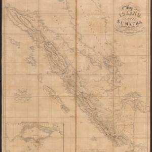
Map of the island of Sumatra constructed chiefly from surveys taken by order of the late Sir Thos. Stamford Raffles
1829
Indonesia, Malaysia, Singapore
On this map of Sumatra, the west coast mountain ranges contrast with the rivers to the east. An inset map of Singapore focuses on jungles along the coasts, and features bathymetry (sea depth) around the south coast and along the Singapore Strait.
- [remove]Jungle/Wooded Area3
- Mountain/Volcano3
- Wetlands1
- Wild Animals1
- [remove]Contour Lines/Elevation3
- Scale3
- Longitude and Latitude2


