Search

Search Results

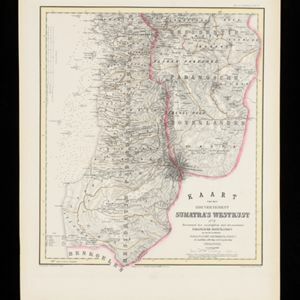
Kaart van de Gouvernement Sumatra's Westkust No. 2

event1857

location_onIndonesia

Map of part of the Dutch colonial administrative region of Sumatra’s Westkust (Sumatra’s West Coast). The sea is marked with bathymetry (sea depth). (From ‘Algemeene Atlas van Nederlandsche Indie [General Atlas of the Dutch East Indies]’.)

Kaart van de Gouvernement Sumatra's Westkust No. 4

event1857

location_onIndonesia

Map of part of the Dutch colonial administrative region of Sumatra’s Westkust (Sumatra’s West Coast). The sea is marked with bathymetry (sea depth). (From ‘Algemeene Atlas van Nederlandsche Indie [General Atlas of the Dutch East Indies]’.)

Kaart van de Residentie Probolinggo

event1856

location_onIndonesia

Map of the Dutch colonial administrative region (residency) of Probolinggo, Java, with an elevation showing the heights of the Tengger mountain range. (From ‘Algemeene Atlas van Nederlandsche Indie [General Atlas of the Dutch East Indies]’.)

Kaart van het Eiland Banka

event1855

location_onIndonesia

Map of the Dutch colonial region of Banka (Bangka) island, featuring bathymetry (sea depth) in the Bangka Strait, and elevations showing heights of mountains. (From ‘Algemeene Atlas van Nederlandsche Indie [General Atlas of the Dutch East Indies]’.)

Kaart van het eiland Java

event1855

location_onIndonesia

Detailed map of Java based on the expeditions of the geologist and botanist Dr. Franz Junghuhn. There are 16 inset maps featuring volcanoes, mountains and coal seams.

Kaart van het eiland Java uit de nieuwste bronnen zamengesteld

event1855

location_onIndonesia

Map of Java divided into administrative areas (‘residencies’ and ‘regencies’). Mountains are represented by hachures, short lines/dashes that give a sense of the shape and steepness of terrain. Postal routes and roads are also marked.

Algemeene Atlas van Nederlandsche Indie

eventc.1853-1862

location_onIndonesia

Atlas featuring over 60 detailed maps of the Dutch East Indies: 24 maps cover Java; the remainder cover the rest of the Dutch East Indies. There are three index maps. (All the maps in this atlas are also presented separately on this platform.)

Kaart der verkennings reizen op Borneo

event1853

location_onIndonesia

Map charting expeditions in southern and eastern Borneo by the German geologist Carl Schwaner in the 1840s. Includes an inset map of rivers and watersheds in central Borneo, nine cross sections of the heights of rivers, and a plan of a gold mine.

Map of Prince of Wales' Island or Pulo Penang and province Wellesley

event1853

location_onMalaysia

Map of the Penang Strait, including written instructions on how to navigate the strait. On land, areas of cultivation are marked, with a table listing acreage used for each crop. A boundary with Siam based on an 1831 treaty is also shown.

Kaart van het gouvernement Sumatra's Westkust

event1850

location_onIndonesia

Two maps covering part of Sumatra’s west coast, divided into administrative districts. Mountains, rivers, settlements and islands off the coast are marked.

close