
Search Results


Plan topographique de l'arrondissement de Saigon
1885
Vietnam
Map of the district of Saigon (Ho Chi Minh City, Vietnam), based around the Fleuve Soirap (Soài Rạp River) as it winds its way down to the South China Sea. The city of Saigon is on its banks, surrounded by more rivers, roads, fields and villages.


Plan topographique de l'arrondissement de Bien-Hoa
1881
Vietnam
Two-sheet map of the district of Bien-Hoa (Biên Hòa) east of Ho Chi Minh City, Vietnam. The area is dominated by rivers, wetlands and mangroves. Labels describe the terrain e.g. ‘Bois marécageux avec rivières [Swampy woods with rivers]’.


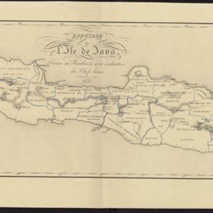
Esquisse de l'ile de Java: divisée en Residences avec indication des chefs-lieux
1833
Indonesia
Map of Java divided into Dutch administrative areas (‘residencies’), and the Empire of Soerakarta and Kingdom of Djokjakarta, which were under indigenous rule (a note records the territories these indigenous areas lost in the Java War (1825–1830)).
- Filter from 1833 to 1899
- [remove]French9
- [remove]Contour Lines/Elevation9
- Longitude and Latitude6
- Scale6
- Compass Rose2
- Written Note/Details1


