
Search Results
35 Results found

Nederlands Oostindische bezittingen, 1848
1848
Brunei, East Timor, Indonesia, Malaysia, Philippines, Singapore
Map of the Dutch East Indies, with blue borders showing the extent of Dutch colonial territory in 1848. It was published by the North Holland Regional Association of the Dutch Teachers' Association.


Nederland en deszelfs koloniën
1844
Brunei, East Timor, Indonesia, Malaysia, Singapore
Map of the East Indies, with the borders of Dutch colonial territory marked in brown. The Malay Peninsula (‘Malakka’) has green borders, indicating it is a British possession. Four inset maps show other Dutch territories outside Southeast Asia.
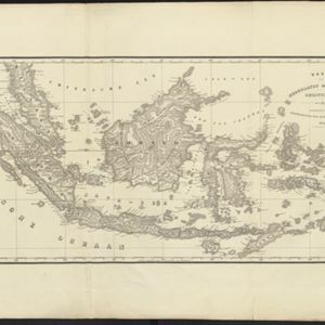
Kaart van Nederlands Oostindische bezittingen
1843
Malaysia, Singapore, Indonesia, East Timor
Map of Dutch colonial possessions in maritime Southeast Asia, labelled with the names of administrative areas. Mountains are represented by hachures, short lines/dashes that give a sense of the shape and steepness of terrain.

Oostindië
1842
Brunei, Cambodia, East Timor, Indonesia, Laos, Malaysia, Myanmar, Philippines, Singapore, Southeast Asia, Thailand, Vietnam
Dutch map of the East Indies, with mountain ranges represented by simple hachure marks, and just a few rivers marked. Mainland Southeast Asia is labelled ‘Achter Indie [Beyond India]’.

Kaart van de Nederlandsche bezittingen in Oost-Indië
1842
Brunei, East Timor, Indonesia, Malaysia, Philippines, Singapore
This map shows the Dutch colonial possessions in the East Indies in the mid-19th century. Other country’s colonial territories are also shown: British (Malacca), Spanish (Philippines) and Portuguese (East Timor). Forts are also marked.
- Filter from 1830 to 1897
- [remove]Contour Lines/Elevation35
- Longitude and Latitude33
- Scale14
- Written Note/Details5
- Compass Rose3


