
Search Results


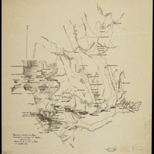
Kaart van de Vallei van Pidië, de Moekim VII en de Vallei van Tangsé
1899
Indonesia
Large-scale topographic map of the northeast coast of Sumatra around the city of Sigli, Aceh, spread over 16 sheets plus a cover sheet of the whole area. The map focuses on two river valleys, mountains, marshland, villages and rice paddies.


Overzichtskaart van Groot-Atjeh en aangrenzende kuststaten
1898
Indonesia
Map of Groot-Atjeh (Aceh, Sumatra), focusing on the area around the capital Kota Radja (Banda Aceh) and along the coasts. There is a list of telephone connections in the area, and an inset map of the region divided into administrative districts.


Kaart van het gebied bezet in Groot-Atjeh, met de nederzettingen Lepoeng en Lehoeng
1897
Indonesia
A map of Groot-Atjeh, Lepoeng and Lehoeng, at the northern tip of Sumatra, detailing routes (rivers, roads, railways), crops (rice, banana, sugarcane, betel, pepper, alang-alang, bamboo) and land features (forests, mountains, wetlands).

Atlas van Nederlandsch Oost-Indië
c.1897-1904
Indonesia
Very detailed atlas of the entire Dutch East Indies, over 16 map sheets, with a cover and overview map. Includes topographic maps, inset maps of cities and islands, and maps featuring land and sea routes, languages, geology, colonial territory etc.

Kaart van het gebied bezet in Groot-Atjeh, met de nederzettingen Lepoeng en Lehoeng
1897
Indonesia
A map of Groot-Atjeh, Lepoeng and Lehoeng, at the northern tip of Sumatra, detailing routes (rivers, roads, railways), crops (rice, banana, sugarcane, betel, pepper, alang-alang, bamboo) and land features (forests, mountains, wetlands).
- Filter from 1839 to 1899
- [remove]Contour Lines/Elevation57
- Scale49
- Longitude and Latitude35
- Written Note/Details17
- Compass Rose8


