
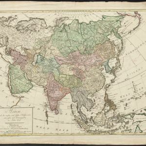
Asien nach den neusten und besten Hülfsmitteln entworffen und herausgegeben im Jahre 1793
1793
Brunei, Cambodia, East Timor, Indonesia, Laos, Malaysia, Myanmar, Papua New Guinea, Philippines, Singapore, Southeast Asia, Thailand, Vietnam
On this map of Asia, borders are outlined and cities underlined in different colours to show the colonial territories of the European powers: e.g. at this time, Benkulen (Bencoolen) on the west coast of Sumatra is British, and Malacca is Dutch.


