Search

Search Results

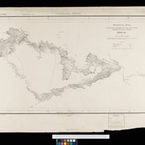
Eastern Naga Hills and Manipur with adjoining portions of Burmah

event1882

location_onMyanmar

This map shows the border between British India and Burmah (Myanmar). Although the Burmah part of the map is mostly blank, the Chindwin River is shown, along with some other details including a label stating ‘Low hills Covered with dense Forest’.

Upper Burma: Preliminary map 1887

event1887

location_onMyanmar

Map of Upper Burma, with the city of Mandalay highlighted in red in the centre, and featuring the Irrawaddy and Chindwin rivers, roads and settlements. Mountains, forests and mines (coal, silver, rubies, amber) are marked.

South eastern frontier

eventc.1890-1906

location_onMyanmar, Thailand

Very detailed large-scale map of the southeast border of Burma (Myanmar) and Siam (Thailand), divided into districts. Spread over multiple sheets, seems incomplete (some sheets appear more than once, probably from different versions of the same map).

South eastern frontier: Reconnaissance survey of the route followed by Lieut. Daly's party towards the China frontier

eventc.1890-1891

location_onMyanmar

A map of the route of a British Army expedition near the border of Upper Burma with China. High points are marked with their heights so they can be used for triangulation. Settlements, rivers, trade routes and footpaths are also shown.

British Burma, Pegu division: With additions to railways up to 1891

event1891

location_onMyanmar

Topographical map of the Pegu Division of British Burma (Myanmar), spread over four sheets. In addition to mountains, forests, rivers and wetlands, rice fields, routes (road, railway, path, telegraph), villages and pagodas are marked.

Map to illustrate Report on Frontier Expedition 1890-91

event1891

location_onMyanmar

Map of the border region between northeast Burma (Myanmar) and China's Yunnan Province, spread over two sheets. The Burma side is more detailed, featuring mountains, rivers and settlements, as well as roads and trade routes.

Map to accompany preliminary report on the Chin-Lushai Country

event1892

location_onMyanmar

Topographical map of the mountainous border region between India and northwest Burma (Myanmar), showing rivers, lakes, villages, towns, roads and railways. High points are marked with their heights so they can be used for triangulation.

Portion of coal fields tract: Upper Chindwin district

event1892

location_onMyanmar

A map surveying coal fields close to the Chindwin River in Upper Burma (Myanmar). Mountains are shown by using hachures: short lines/dashes that give a sense of the shape and steepness of terrain. Survey stations are marked with their height.

District Bhamo

event1893

location_onMyanmar

Map of the district of Bhamo in northern Burma (Myanmar) featuring the Irrawaddy River, railways (proposed and under construction, including the future Burma State Railway), and mines (amber, jade).

District Ruby Mines

event1893

location_onMyanmar

Map of the district of Ruby Mines in northern Burma (Myanmar) featuring the Irrawaddy and Shweli rivers. High points are marked with their heights so they can be used for triangulation. As the name suggests, the district was known for its rubies.

Indo-China

event1893

location_onCambodia, Laos, Myanmar, Thailand, Vietnam, Malaysia

Topographical map of mainland Southeast Asia. Mountains are represented by hachures—short lines/dashes that give a sense of the shape and steepness of terrain—and settlements, roads and rivers are marked.

Upper Burma

event1893

location_onMyanmar, Thailand

Map of Upper Burma, showing the borders with Assam (India), China and Siam (Thailand), as well as internal administrative borders. Mountains with their heights, settlements, rivers and railways (completed, proposed and under construction) are shown.

close

  • Filter from 1883 to 1900

Current results range from 1883 to 1900