
Search Results


Itinéraires de Mr A. Pavie dans le Sud-Ouest l'Indo-Chine Orientale (Cambodge et Siam) (1880-1884)
1884
Thailand, Cambodia
The routes taken by the French civil servant and explorer Auguste Pavie are marked on this map of Siam (Thailand) and Cambodge (Cambodia), along with the telegraph line that he subsequently constructed from Pnom Penh (Phnom Penh) to Bangkok.

Carte générale de l'Océan Pacifique
1845
Brunei, Cambodia, East Timor, Indonesia, Laos, Malaysia, Myanmar, Papua New Guinea, Philippines, Singapore, Southeast Asia, Thailand, Vietnam
Marine chart of the Pacific Ocean, including Southeast Asia. Small islands, shoals and reefs are marked, and often named, around the seas and straits of the region.
Carte des possessions et etablissemens du Roi des Pays-Bas aux Indes Orientales
1839
Brunei, East Timor, Indonesia, Malaysia, Singapore
Map of the Dutch East Indies featuring maritime routes from the Sunda Strait and Batavia (Jakarta) to the Maluku or Spice Islands (Ambon, Ternate etc.). There is an eastern route (taken from October to March) and a return route (December to March).
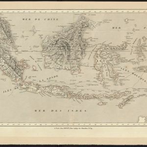

- Filter from 1775 to 1899
- [remove]Contour Lines/Elevation6
- Longitude and Latitude6
- Scale4
- Compass Rose1
- Rhumbline Network1
- Written Note/Details1


