
Search Results

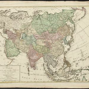
Asien nach den neusten und besten Hülfsmitteln entworffen und herausgegeben im Jahre 1793
1793
Brunei, Cambodia, East Timor, Indonesia, Laos, Malaysia, Myanmar, Papua New Guinea, Philippines, Singapore, Southeast Asia, Thailand, Vietnam
On this map of Asia, borders are outlined and cities underlined in different colours to show the colonial territories of the European powers: e.g. at this time, Benkulen (Bencoolen) on the west coast of Sumatra is British, and Malacca is Dutch.

Chart of Pulo Penang: now Prince of Wales's Island
1805
Malaysia
Map focusing on the passage between Penang Island and the mainland, with shoals and reefs marked and described, and bathymetry (sea depth) shown. There are anchor points at George Town harbour, and landmarks—hills, trees, a fort—to aid navigation.

A new chart shewing the navigation through the Strait of Sunda to Batavia
1815
Indonesia
Navigation chart of the Sunda Strait, with sea depth, anchor points, shoals and other obstructions. Includes many bays, with four highlighted on inset maps. Partly based on writings of Captain Krusenstern whose 1806 route through the strait is shown.


A map of Java: chiefly from surveys made during the British administration
1817
Indonesia
Made for ‘A History of Java’ by Sir Stamford Raffles, this map includes a list of administrative districts with their populations, and four inset maps of harbours. Another inset map shows rocks and minerals, mountains and volcanoes, and teak forests.

A plan of soundings from Pulo Aor to the Southward, and outside of the Reef off Point Romania towards the entrance of Sincapour Strait
1818
Malaysia, Indonesia, Singapore
Navigation chart of part of the South China Sea leading to the eastern entrance of the Singapore Strait. Features bathymetry (sea depth), anchor points, shoals and other obstructions, landmark hills, and detailed explanatory notes.
- [remove]Contour Lines/Elevation290
- Longitude and Latitude245
- Scale242
- Written Note/Details73
- Compass Rose50
- Rhumbline Network3


