
Search Results
550 Results found

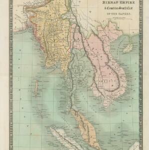
Birman Empire & countries south east of the Ganges
1834
Cambodia, Indonesia, Laos, Malaysia, Myanmar, Singapore, Thailand, Vietnam
A 19th century map of mainland Southeast Asia, showing the ancient kingdoms of the Birman Empire (roughly modern Myanmar), Malaya (Malaysia), Siam (Thailand), Cochin China and Tonquin (Vietnam), and the Anamese Empire (Cambodia and Laos).
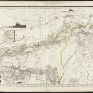
Karte von Assam: und seinen Nachbar-Ländern
1834
-
Map of Assam, including India’s border with northwest Birma (Myanmar) where indigenous lands/peoples are marked (Singphos, Naga, Kasi-Schan, Thai-Lung) e.g. ‘These mountainous landscapes are inhabited by the Naga tribes [translation from map text]’.

China, Birmah and Anam
1835
Cambodia, Laos, Myanmar, Thailand, Vietnam, Philippines
Coloured borders are used on this map to divide mainland Southeast Asia into empires and kingdoms. Mountains, rivers and major settlements are shown in land, with islands, shoals and reefs marked in the South China Sea.

Ost-Indien mit den Inseln
c.1835
Brunei, Cambodia, East Timor, Indonesia, Laos, Malaysia, Myanmar, Philippines, Singapore, Southeast Asia, Thailand, Vietnam
On this map of India and Southeast Asia, borders are outlined and cities underlined in different colours to show the colonial territories of the European powers. On Borneo, the names of indigenous peoples are listed (‘Dayak’s, Papua’s, Bugi’s’).

Reduzirte Karte vom Sunda- oder Borneo-Meere
1835
Malaysia, Indonesia
A navigation map of the Java Sea and Sunda Islands, with bathymetry (sea depth), maritime routes, shoals and reefs, and elevations (side views of terrestrial landmarks). Inset maps feature the bay at Batavia and the straits between the Sunda Islands.

Reduzirte Karte vom Sunda- oder Borneo-Meere
1835
Indonesia, Malaysia
A navigation map of the Java Sea and Sunda Islands, with bathymetry (sea depth), maritime routes, shoals and reefs, and elevations (side views of terrestrial landmarks). Inset maps feature the bay at Batavia and the straits between the Sunda Islands.
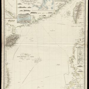
Reduzirte Karte vom Chinesischen Meere: 2tes Blatt, den Nördlichen Theil enthalted
1835
Vietnam, Philippines
Navigation map of the northern South China Sea, with bathymetry (sea depth), islands, shoals and reefs. There are five maritime routes to Canton and one to Manilla marked, and inset maps of the Gulf of Tonkin and bays and islands in the Philippines.
- Filter from 1775 to 1900
- Indonesia442
- Malaysia162
- Myanmar146
- Singapore126
- Thailand123
- Brunei104
- Vietnam104
- Philippines98
- Laos95
- Cambodia93
- East Timor93
- Southeast Asia69
- more Simple Location »
- Port61
- Railway Station29
- Pier16
- River469
- Road264
- Path167
- Railway/Tramway103
- Postal Route86
- Telegraph/Telephone41
- Canal31
- Bridge26
- [remove]Contour Lines/Elevation550
- Longitude and Latitude480
- Scale459
- Written Note/Details137
- Compass Rose72
- Rhumbline Network5


