
Search Results
550 Results found

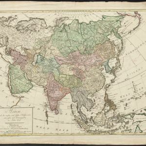
Asien nach den neusten und besten Hülfsmitteln entworffen und herausgegeben im Jahre 1793
1793
Brunei, Cambodia, East Timor, Indonesia, Laos, Malaysia, Myanmar, Papua New Guinea, Philippines, Singapore, Southeast Asia, Thailand, Vietnam
On this map of Asia, borders are outlined and cities underlined in different colours to show the colonial territories of the European powers: e.g. at this time, Benkulen (Bencoolen) on the west coast of Sumatra is British, and Malacca is Dutch.

A chart of north-west coast of Borneo: from Balambangan to Borneo proper
1794
Malaysia
Nautical charts, like this late 18th century example of the north-west coast of Borneo, were designed to help ships navigate. The numbers marked along the coastline and sea routes indicate the depth of the sea (bathymetry).


A new map of the East India Isles
1801
Brunei, Cambodia, East Timor, Indonesia, Laos, Malaysia, Myanmar, Vietnam, Thailand, Southeast Asia, Singapore, Philippines
An early 19th century map by the English cartographer John Cary, highlighting the mountain ranges and rivers of Southeast Asia. The map also features many place names of cities, towns and islands.

Chart of Pulo Penang: now Prince of Wales's Island
1805
Malaysia
Map focusing on the passage between Penang Island and the mainland, with shoals and reefs marked and described, and bathymetry (sea depth) shown. There are anchor points at George Town harbour, and landmarks—hills, trees, a fort—to aid navigation.

The continent and islands of Asia: with all the latest discoveries
1809
Vietnam, Myanmar, Papua New Guinea, Philippines, Singapore, Southeast Asia, Thailand, Malaysia, Laos, Indonesia, East Timor, Cambodia, Brunei
Southeast Asia is on the last sheet of this map of Asia. The South China Sea is labelled ‘Malayan Sea’. Small islands, shoals and reefs are shown. A label in Cochin China (Vietnam) reads ‘mountains inhabited by the uncivilized people called Kemoys’.

Asia
1814
Brunei, Cambodia, Indonesia, Laos, Malaysia, Myanmar, Philippines, Singapore, Southeast Asia, Thailand, Vietnam
An early 19th century map, with the regions of Southeast Asia marked with coloured borders: Malaya is red, indicating it is part of the British Empire; the orange borders around Sumatra, Borneo and Celebes show they are part of the Dutch East Indies.
- Filter from 1775 to 1900
- Indonesia442
- Malaysia162
- Myanmar146
- Singapore126
- Thailand123
- Brunei104
- Vietnam104
- Philippines98
- Laos95
- Cambodia93
- East Timor93
- Southeast Asia69
- more Simple Location »
- Port61
- Railway Station29
- Pier16
- River469
- Road264
- Path167
- Railway/Tramway103
- Postal Route86
- Telegraph/Telephone41
- Canal31
- Bridge26
- [remove]Contour Lines/Elevation550
- Longitude and Latitude480
- Scale459
- Written Note/Details137
- Compass Rose72
- Rhumbline Network5


