
Search Results


A new chart of the north coast of Java: wherein are described the roads of Bantam and Batavia
1794
Indonesia
Map of the Batavia (Jakarta) and Bantam (Bantem) roadsteads (a body of water sheltered from tides/currents, for ships to anchor). Shoals, reefs and bathymetry (sea depth) are marked, with explanatory notes and a rhumbline network to aid navigation.

A new chart containing the southwest part of the China Sea comprised between the Malaya Peninsula, Straits of Singapore &c. the Straits of Banca, Gaspar and Billiton and the Isle of Borneo
1794
Indonesia
A map of the China Sea between Malaya, Sumatra and Borneo. The numbers indicate sea depth (bathymetry), and there are drawings of the side views of some of the islands (elevations), both used to aid navigation. Some maritime routes are also marked.
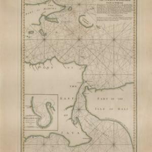
A new plan of the Straits, situated to the east of Java & Madura commonly called the Straits of Bali and of Pondi and Respondi
1794
Indonesia
A late 18th century navigation map of the waters between the islands of Java, Madura and Bali. The web of lines is a rhumbline network, the numbers indicate sea depth (bathymetry), and there is an inset map of the Bay of Ballambouang, Java.
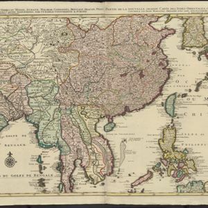
La nouvelle grande carte des Indes Orientales
1792
Cambodia, Laos, Myanmar, Philippines, Thailand, Vietnam
Map of mainland Southeast Asia divided into kingdoms. Larger settlements are marked pictorially with a red building symbol. The desert of Cochinchine (Vietnam) is labelled as being inhabited by the ‘Kemoys Peuples Barbares [Kemoys Barbarian People]’.

A new chart of the Oriental Seas and Islands... from the Isle of Ceylon to Amoye in China
1790
Brunei, Cambodia, East Timor, Indonesia, Laos, Malaysia, Myanmar, Philippines, Singapore, Southeast Asia, Thailand, Vietnam
A late 18th century maritime map of Southeast Asia, marked with expedition routes including the return of Captain Cook’s HMS Endeavour from Australia in 1770, and Captain Philip Carteret’s circumnavigation expedition in 1768.

Carte du Détroit de la Sonde, depuis la pointe de Winerou jusques à l'Isle du Nord
c.1790
Indonesia
Navigation chart of the Sunda Strait, focusing on bays and islands, and showing bathymetry (sea depth), anchor points, shoals and reefs. Includes an inset map of the bay of the Isle de Mew (Peucang Island). The web of lines is a rhumbline network.

Plan of the road and city of Batavia on the north coast of Java Island
1790
Indonesia
Map of the Batavia (Jakarta) Bay roadstead, a body of water sheltered from tides/currents, for ships to anchor. The web of lines is a rhumbline network, the numbers indicate sea depth (bathymetry), and there are written notes, all to aid navigation.
Carte du Détroit de la Sonde, depuis la pointe de Winerou jusques à l'Isle du Nord
c.1790
Indonesia
Navigation chart of the Sunda Strait, focusing on bays and islands, and showing bathymetry (sea depth), anchor points, shoals and reefs. Includes an inset map of the bay of the Isle de Mew (Peucang Island). The web of lines is a rhumbline network.
Plan of the road and city of Batavia on the north coast of Java Island
1790
Indonesia
Map of the Batavia (Jakarta) Bay roadstead, a body of water sheltered from tides/currents, for ships to anchor. The web of lines is a rhumbline network, the numbers indicate sea depth (bathymetry), and there are written notes, all to aid navigation.
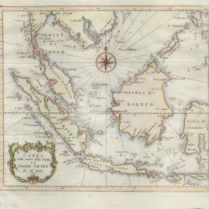
Carta dello stretto della Sonda, ed isole vicine
1781
Brunei, Cambodia, Indonesia, Malaysia, Myanmar, Philippines, Singapore, Thailand, Vietnam
A late 18th century map of maritime Southeast Asia by the French geographer Jacques Nicolas Bellin (1703–1772). The title refers to the ‘Stretto della Sonda’ (Sunda Strait), the strait between the islands of Sumatra and Java.
- Filter from 1595 to 1899
- Indonesia332
- Malaysia224
- Singapore189
- Thailand184
- Cambodia180
- Vietnam180
- Brunei174
- Philippines174
- East Timor163
- Myanmar161
- Laos148
- Southeast Asia142
- more Simple Location »
- Sumatra229
- Java216
- Borneo211
- Malay Peninsula174
- Sulawesi172
- Celebes144
- Malacca114
- Siam113
- Western New Guinea110
- Maluku Islands97
- Pegu97
- Sunda Islands71
- more Detailed Location »
- [remove]Compass Rose371
- [remove]Longitude and Latitude371
- Scale261
- Rhumbline Network112
- Written Note/Details93
- Contour Lines/Elevation63


