
Search Results
4 Results found

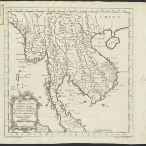
Carte de l'Inde au-delà du Gange comprenant les Royaumes de Siam, de Tunquin, Pegu, Ava, Aracan &c.
c.1757
Cambodia, Laos, Malaysia, Myanmar, Thailand, Vietnam
The kingdoms of mid-18th century mainland Southeast Asia are shown on this map: Ava and Pegu (Myanmar), Siam (Thailand), Tonquin and Cochinchine (Vietnam), Camboie (Cambodia) and Laos. Rivers are also prominent, and mountains are shown pictorially.
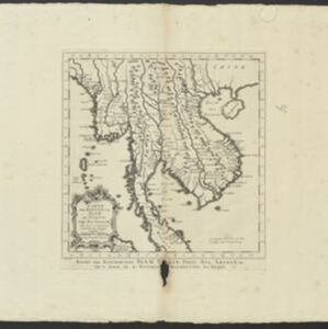
Carte des Royaumes de Siam, de Tunquin, Pegu, Ava, Aracan &c.
c.1755
Cambodia, Laos, Malaysia, Myanmar, Thailand, Vietnam
The kingdoms of mid-18th century mainland Southeast Asia are shown on this map: Ava and Pegu (Myanmar), Siam (Thailand), Tonquin and Cochinchine (Vietnam), Camboie (Cambodia) and Laos. The text is in French, with the title also in Dutch at the base.
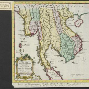
- Filter from 1755 to 1772
- [remove]River4
- [remove]Longitude and Latitude4
- Scale4
- Compass Rose1
- Bellin, Jacques Nicolas4
- [remove]Schley, Jacobus van der4
- Du Bois, J.P.J.1
- Prévost, Abbé1


