Search Results
Filter
Map Attributes
Longitude and Latitude
Remove constraint Map Attributes: Longitude and Latitude
Cultivation/Extraction
Agricultural Pond
Remove constraint Cultivation/Extraction: Agricultural Pond
Land Routes
Bridge
Remove constraint Land Routes: Bridge
Settlement Features
Residential Area
Remove constraint Settlement Features: Residential Area
3 Results found

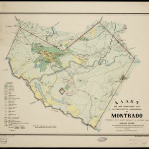
Kaart van den vierkanten paal gouvernements-grondgebied te Montrado
1887
Indonesia
A map of government land around the town of Montrado, Borneo, a gold mining centre in the 19th century, as shown by the number of gold mines (‘goudmijn’) marked. There are also crops—coconut, alang-alang, bamboo—and agricultural and fish ponds.
- Filter from 1887 to 1899
- Kampong/Village3
- [remove]Residential Area3
- Cemetery/Columbarium2
- Temple2
- Church1
- Hospital1
- Jail/Prison1
- Military Fort1
- Mosque1
- Post Office1
- Well1
- [remove]Agricultural Pond3
- Crops2
- Plantation/Forestry Area2
- Fishing1
- Mining1
- [remove]Longitude and Latitude3
- Scale3
- Contour Lines/Elevation2


