
Search Results


Westkust Celebes: Vaarwaters benoorden Makasser: Blad II
1898
Indonesia
Navigation map of the west coast of Celebes (Sulawesi), north of Makassar. Bathymetry (sea depth), shoals and other obstructions are marked, with hills and settlements as landmarks, and elevations (side views of hills) to aid navigation.

Westkust Celebes: Vaarwaters benoorden Makasser: Blad I
1898
Indonesia
Navigation map of the west coast of Celebes (Sulawesi), north of Makassar. Bathymetry (sea depth), lighthouses, shoals and other obstructions are marked, with trees and hills as landmarks, and elevations (side views of hills) to aid navigation.

Het stroomgebied van Bila en Pane: Opgenomen en in kaart gebracht... gedurende de jaren 1876, 1877, 1878, 1882, 1883, 1884
1885
Indonesia
A map of the watershed of the Bila and Pane rivers in northern Sumatra. In addition to many rivers/tributaries, mountains, roads, paths and administrative borders are marked. Side views of mountains (elevations) are shown to use a landmarks.

Midden-Sumatra: Reizen en onderzoekingen der Sumatra-expeditie... 1877-1879
1882
Indonesia
An Atlas produced by an expedition in central Sumatra, including: maps of topography, geology, a number of rivers in the region; drawings of mountains, graphs of lengths of roads; family trees of the royal families of Djambi (Jambi) and Palembang.

Geognostische kaart van het Oembilien kolenveld in de Padangsche bovenlanden, Sumatra's Westkust
1874
Indonesia
A geological map, spread over eight sheets, showing the types of rock and minerals found in the Oembilien coalfield, in the Padang Highlands on Sumatra’s west coast. There are also additional geological profiles.

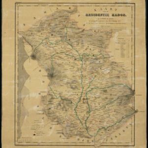


Kaart van assistent-residentie Patjitan
1859
Indonesia
Map of the residency of Patjitan (Pacitan), south coast of East Java, divided into administrative districts. At the base, there is an elevation (side view) drawing of terrain around the Bay of Patjitan. Villages, forts and ruined temples are marked.

Kaart van de Westerhelft der Residentie Samarang
1858
Indonesia
Map of the Dutch colonial administrative region (residency) of Samarang (Semarang, Java), with post offices and routes, a saw mill and a sugar factory marked. (From ‘Algemeene Atlas van Nederlandsche Indie [General Atlas of the Dutch East Indies]’.)

Kaart van de Oosterhelft der Residentie Samarang
1858
Indonesia
Map of the Dutch colonial administrative region (residency) of Samarang (Semarang, Java) with ruined temples, a sugar factory, tobacco warehouse and rice mill. (From ‘Algemeene Atlas van Nederlandsche Indie [General Atlas of the Dutch East Indies]’.)
- Filter from 1700 to 1899
- [remove]Elevation40
- Legend27
- Inset Map8
- Illustration7
- Coat of Arms4
- [remove]Longitude and Latitude40
- Contour Lines/Elevation38
- Scale37
- Written Note/Details10
- Compass Rose5
- Rhumbline Network1


