
Search Results


De landvoogdy van Amboina met de elf onderhoorige eylanden
1726
Indonesia
Although mainly a navigation map—with a rhumbline network and elevations of mountains—there are also many terrestrial details shown, such as settlements and mountains. The inset map of Hoeamohel details plantations and the cultivation of nut crops.


Insulae Iavae Pars Occidentalis / Insulae Iavae Pars Orientalis
c.1720
Indonesia
A map of Java with mountains, jungles, animals and crops. Bathymetry (sea depth) is marked, including on an inset map of Batavia harbour. Illustrations include Batavia Castle, and a lion—representing Belgium—receiving tribute and enslaving locals.

Carte de l'ile de Java: partie occidentale, partie orientale, dressée tout nouvellement sur les mémoires les plus exacts
1720
Indonesia
The mountains and forests of early 18th century Java are beautifully illustrated here by the Dutch cartographer Henry Abraham Chatelain (1648-1743). Details include cities, fields of crops, animals and people. An inset map shows the port of Batavia.
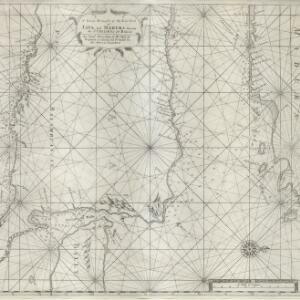
A large draught of the east end of Java and Madura shewing the Streights of Bally
1711
Indonesia
This early 18th century maritime map charts the waters between the islands of Java, Madura and Bally (Bali). The web of lines is a rhumbline network, while the numbers indicate sea depth (bathymetry), both used to aid navigation.

Insulae Iavae pars Occidentalis
c.1710-1719
Indonesia
A map of Java with mountains, jungles, animals and crops. Bathymetry (sea depth) is marked, including on an inset map of Batavia harbour. Illustrations include Batavia Castle, and a lion—representing Belgium—receiving tribute and enslaving locals.

[Portolan chart of the South China Sea]
1701
Brunei, Cambodia, Indonesia, Laos, Malaysia, Philippines, Thailand, Vietnam
Hand-drawn portolan (nautical) chart, featuring a rhumbline network (the web of interconnected lines), bathymetry (sea depth), shoals and reefs, names of coastal settlements, and an elevation (side view) of a mountain at the north tip of Borneo.

- Filter from 1700 to 1899
- [remove]Elevation134
- Legend52
- Inset Map43
- Illustration26
- Coat of Arms18
- Cartouche7
- [remove]Longitude and Latitude134
- Scale98
- Contour Lines/Elevation83
- Compass Rose64
- Written Note/Details42
- Rhumbline Network32


