
Search Results


Carte de l'ile de Java et des autres possessions orientales du Royaume des Pays-Bas
1830
Indonesia, Malaysia, Philippines, East Timor, Singapore
A French map of the Asian colonial possessions of the Netherlands (Dutch East Indies), with an inset map of the island of Java. Colonies of Britain (Malay Peninsula), Spain (the Philippines) and Portugal (parts of Floris and Timor) are also marked.

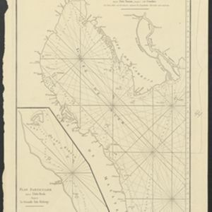
Carte du Détroit de la Sonde, depuis la pointe de Winerou jusques à l'Isle du Nord
c.1790
Indonesia
Navigation chart of the Sunda Strait, focusing on bays and islands, and showing bathymetry (sea depth), anchor points, shoals and reefs. Includes an inset map of the bay of the Isle de Mew (Peucang Island). The web of lines is a rhumbline network.
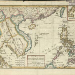
Les Isles Philippines, celle de Formose, le sud de la Chine, les Royaumes de Tunkin, de Cochinchine, de Cambodge, de Siam, des Laos: avec partie de ceux de Pegu et d'Ava
1780
Indonesia, Cambodia, Laos, Malaysia, Myanmar, Philippines, Thailand, Vietnam
Coloured borders on this map show the kingdoms of mainland Southeast Asia and the Philippines. Arrows marked on the sea to the west of the Philippines indicate wind direction during the monsoon seasons (with the months marked in French).
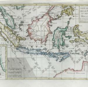
Carte des isles de la Sonde et des isles Moluques
1780
Brunei, Cambodia, East Timor, Indonesia, Malaysia, Philippines, Singapore
The arrows on this map mark the direction of the seasonal monsoons experienced around the Sunda and Maluku Islands (mainly modern Indonesia) during the late 18th century. Each arrow has a label in French, indicating the month.

Carte d'Asie divisée en ses principaux etats
1776
Myanmar, Papua New Guinea, Philippines, Singapore, Southeast Asia, Thailand, Vietnam, Malaysia, Laos, Indonesia, East Timor, Cambodia, Brunei
The 20 colourful illustrations around the border of this 18th century map of Asia depict a variety of historical and biblical scenes, including the Crucifixion of Jesus and the sacking of Troy. Each scene has a description in French and Spanish.
Carte Plate du Golfe de Siam: avec une partie des Côtes de Malaye et de Camboje, depuis l'Isle Timon, jusqu'à celle Condor
1775
Cambodia, Malaysia, Thailand
Map of the Gulf of Siam (Gulf of Thailand) with shoals and small islands marked. The web of lines is a rhumbline network, while the numbers indicate sea depth (bathymetry), both used to aid navigation. There is an inset map of the Redang Archipelago.
- Filter from 1652 to 1850
- [remove]Inset Map28
- Cartouche8
- Illustration8
- Legend2
- Elevation1
- [remove]Longitude and Latitude28
- Scale23
- Compass Rose15
- Written Note/Details6
- Contour Lines/Elevation4
- Rhumbline Network4


