
Search Results
28 Results found


Overzichtskaart van Groot-Atjeh en aangrenzende kuststaten
1898
Indonesia
Map of Groot-Atjeh (Aceh, Sumatra), focusing on the area around the capital Kota Radja (Banda Aceh) and along the coasts. There is a list of telephone connections in the area, and an inset map of the region divided into administrative districts.

Atlas van Nederlandsch Oost-Indië
c.1897-1904
Indonesia
Very detailed atlas of the entire Dutch East Indies, over 16 map sheets, with a cover and overview map. Includes topographic maps, inset maps of cities and islands, and maps featuring land and sea routes, languages, geology, colonial territory etc.

A Map of the Malay Peninsula
1897
Indonesia, Malaysia, Singapore, Thailand
On this late 19th century map of the Malay Peninsula, the British colonial territories—the Straits Settlements of Singapore, Malacca, Dinding and Penang—are in red, demarcating them from the British protectorate states of the rest of the peninsula.

Kaart van de residentie Oostkust van Sumatra
1896
Indonesia
Detailed topographical map of the east coast of Sumatra, spread over 36 sheets. The area’s farms are listed and shown on the map within yellow borders, with types of crop grown. There is a detailed plan of Medan, and five inset maps of other towns.

Sumatra: Residentie Benkoelen (Bengkoelen)
c.1894-1895
Indonesia
Map of the residency of Benkoelen (Bengkulu, southwest coast of Sumatra), over 10 sheets, with an inset map of the city of Bengkoelen (Bengkulu). Types of crops—coconut, rice, alang-alang, nipah palm, coffee—are marked. Sheet number 8 is missing.
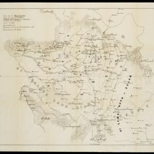
Kaart van de Karo landen (Oost Sumatra)
1891
Indonesia
A map recording five Dutch expeditions through the Karo Lands of northern Sumatra. The mountainous terrain is represented by contour lines, with peaks’ heights marked. The names of groups of the indigenous Karo people are shown in large letters.

Kaart der Bataklanden en van het eiland Nijas
1890
Indonesia
A large-scale map of northern Sumatra, spread over 16 sheets, and divided into administrative regions. The island of Nijas (Nias) is marked with the locations of local tribes, and there is a list of other maps referenced in producing the map.

Kaart van de residentie Oostkust van Sumatra
1889
Indonesia
Detailed topographical map of the east coast of Sumatra, spread over 34 sheets. The area’s farms are listed and shown on the map, with types of crop grown. With five inset maps of individual towns. Two sheets and the cover sheet are missing.

Kaart van de residentie Oostkust van Sumatra
1889
Indonesia
Detailed topographical map of the east coast of Sumatra, spread over 36 sheets plus a cover sheet of the whole area. Mountains and forests dominate, with villages, routes and administrative borders shown. With five inset maps of individual towns.

- Filter from 1839 to 1899
- [remove]Longitude and Latitude28
- Contour Lines/Elevation27
- Scale23
- Written Note/Details14
- Compass Rose3


