
Search Results
19 Results found


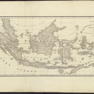
Carte générale des possessions néerlandaises aux Indes orientales
1846
Brunei, East Timor, Indonesia, Malaysia, Philippines, Singapore
Map of the Asian colonial possessions of the Netherlands (Dutch East Indies), with an inset of the heights of some of the region’s mountains. A note describes the average temperature, barometer reading and magnetic declination in Batavia at the time.
Kaart van Nederlands Oostindische bezittingen
1843
Malaysia, Singapore, Indonesia, East Timor
Map of Dutch colonial possessions in maritime Southeast Asia, labelled with the names of administrative areas. Mountains are represented by hachures, short lines/dashes that give a sense of the shape and steepness of terrain.
- Filter from 1750 to 1867
- [remove]District/Administrative Border19
- Colonial Possessions17
- Civic/Metropolitan Border4
- Regional Border4
- National Border2
- [remove]Longitude and Latitude19
- Contour Lines/Elevation17
- Scale14
- Written Note/Details8
- Compass Rose3


