Search Results
![](https://historicalmaps.yale-nus.edu.sg/rails/active_storage/representations/eyJfcmFpbHMiOnsibWVzc2FnZSI6IkJBaHBBbnNDIiwiZXhwIjpudWxsLCJwdXIiOiJibG9iX2lkIn19--557a5302af896a1447abf01adec7f73d14c334c1/eyJfcmFpbHMiOnsibWVzc2FnZSI6IkJBaDdCam9MY21WemFYcGxTU0lNTkRBd2VETXdNQVk2QmtWVSIsImV4cCI6bnVsbCwicHVyIjoidmFyaWF0aW9uIn19--8e68de2000a6e968bae6c9034cc043e081a6a0fb/leiden-2012699.jpeg)
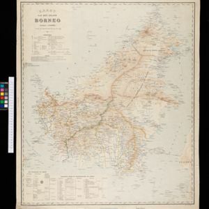
Kaart der residentie Zuider- en Ooster-afdeeling van Borneo
1899
Indonesia
On this map, the residency of South and East Borneo is divided into departments (green borders) and provinces (yellow borders). There is an inset plan of the city of Banjarmasin, with rivers, buildings, residential areas, roads and crops marked.
![](https://historicalmaps.yale-nus.edu.sg/rails/active_storage/representations/eyJfcmFpbHMiOnsibWVzc2FnZSI6IkJBaHBBalVFIiwiZXhwIjpudWxsLCJwdXIiOiJibG9iX2lkIn19--98827f811c8e2a0c9d4bea0f91a40d141b85024e/eyJfcmFpbHMiOnsibWVzc2FnZSI6IkJBaDdCam9MY21WemFYcGxTU0lNTkRBd2VETXdNQVk2QmtWVSIsImV4cCI6bnVsbCwicHVyIjoidmFyaWF0aW9uIn19--8e68de2000a6e968bae6c9034cc043e081a6a0fb/leiden-2012011.jpeg)
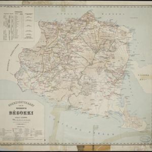
Overzichtskaart van de Residentie Besoeki
1899
Indonesia
This map of the residency of Besoeki (Banyuwangi Regency, East Java) is divided into regencies and districts. Heights of mountains and settlements are given in metres, and distances are shown along roads. Sugar factories and fishing ponds are marked.
![](https://historicalmaps.yale-nus.edu.sg/rails/active_storage/representations/eyJfcmFpbHMiOnsibWVzc2FnZSI6IkJBaHBLUT09IiwiZXhwIjpudWxsLCJwdXIiOiJibG9iX2lkIn19--91097fc832f648c6f7bdd1153ae21fdd455e26e2/eyJfcmFpbHMiOnsibWVzc2FnZSI6IkJBaDdCam9MY21WemFYcGxTU0lNTkRBd2VETXdNQVk2QmtWVSIsImV4cCI6bnVsbCwicHVyIjoidmFyaWF0aW9uIn19--8e68de2000a6e968bae6c9034cc043e081a6a0fb/bodleian-0038.jpeg)
A map of the Malay Peninsula
1898
Malaysia, Singapore, Thailand
Map of the Malay Peninsula showcasing the Straits Settlements in pink, the Federated Malay States in red, and Siamese states in yellow. A table of common words in English, Malay and Siamese is included. Only four of six sheets are available.
- Dutch East Indies126
- Java74
- Sumatra33
- Borneo16
- Java Sea15
- Celebes10
- Sulawesi10
- West Kalimantan10
- Java Zee9
- Lesser Sunda Islands9
- Madura9
- Lombok8
- more Detailed Location »
- Kampong/Village123
- Residential Area53
- Post Office52
- Cemetery/Columbarium45
- Military Fort34
- Military Barracks26
- Temple25
- Hospital23
- Church21
- Mosque19
- Jail/Prison17
- Public Space12
- Palace11
- Police Station10
- more Settlement Features »
- [remove]Path163
- Road155
- River154
- Postal Route68
- Railway/Tramway55
- Canal20
- Telegraph/Telephone20
- Bridge19
- [remove]Longitude and Latitude163
- Scale151
- Contour Lines/Elevation143
- Written Note/Details46
- Compass Rose7
- Versteeg, W.F.29
- Cronenberg, F.24
- Wolff15
- Böhm12
- Frühling, P.7
- Ostreig5
- Bajetto, G.F.M.4
- Donnadieu3
- more Map Maker »
- Topographische Inrichting46
- Topographische Bureau44
- Van Haren Noman & Kolff26
- A.J. Bogaerts15
- D. Heyse8
- Survey of India Offices, Calcutta8
- Emrik & Binger6
- Seyffardt's Boekhandel4
- more Printer/Publisher »
- Batavia74
- The Hague50
- Amsterdam9
- Dehradun4
- London3
- Breda2
- Singapore2
- Zutphen2
- more Place of Publication »