
Search Results
31 Results found


Carte générale des possessions néerlandaises aux Indes orientales
1846
Brunei, East Timor, Indonesia, Malaysia, Philippines, Singapore
Map of the Asian colonial possessions of the Netherlands (Dutch East Indies), with an inset of the heights of some of the region’s mountains. A note describes the average temperature, barometer reading and magnetic declination in Batavia at the time.
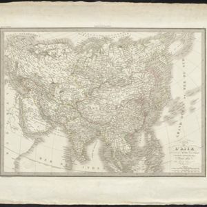
Carte de l'Asie
1831
Brunei, Cambodia, Indonesia, Laos, Malaysia, Myanmar, Philippines, Singapore, Thailand, Vietnam, Southeast Asia
The ancient kingdoms of mainland Southeast Asia are shown on this map of Asia, including the Birman Empire (Myanmar), the Kingdom of Siam (Thailand), and the Empire of Annam (Vietnam).

Carte du Grand Archipel d'Asie (Partie Nord-ouest de l'Océanie)
1826
Southeast Asia, Malaysia, Indonesia, Vietnam
Colonial possessions of the Dutch, Spanish and Portuguese, as well as lands of ‘indigenous princes’ are marked with coloured borders on this map of maritime Southeast Asia. Hot springs and mineral water springs in Java are also listed.

Carte physique et politique de l'Asie
1822
Brunei, Cambodia, Indonesia, Laos, Malaysia, Myanmar, Papua New Guinea, Philippines, Singapore, Thailand, Vietnam, Southeast Asia
This map of Asia features the ancient kingdoms of mainland Southeast Asia, such as the Birman Empire, Siam, Tonquin and Cochinchina. There are labels noting the inhabitants of some areas, such as 'Biajos' and ‘Tedongs’ in Borneo, and ‘Kemoy’ in Anam.

- Filter from 1692 to 1889
- Borneo31
- [remove]South China Sea31
- [remove]Sumatra31
- Malay Peninsula27
- Java25
- Maluku Islands20
- Sulawesi20
- Western New Guinea19
- Mer de la Chine18
- Sunda Islands18
- Malacca17
- Isles de la Sonde16
- more Detailed Location »
- [remove]River31
- [remove]Longitude and Latitude31
- Scale25
- Compass Rose10
- Written Note/Details8
- Contour Lines/Elevation5


