
Search Results
11 Results found


Kaart van Nederlandsch-Indie
1893
Brunei, Cambodia, Indonesia, Malaysia, Singapore, Thailand, Vietnam, East Timor, Philippines, Southeast Asia
Shipping routes are the focus of this map of the Dutch East Indies, indicated by red lines labelled with the name of the shipping company and the destinations. Parcel shipping routes are also shown. Inset maps feature railway lines too.


Kaart van den Indischen Archipel
1830
Brunei, Cambodia, East Timor, Indonesia, Laos, Malaysia, Myanmar, Philippines, Singapore, Southeast Asia, Thailand, Vietnam
This map shows the Dutch colonial possessions or dependencies in the East Indies during the early 19th century. Areas not coloured red remained under local rulers or were colonies of other European powers.
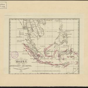
- Filter from 1830 to 1898
- Dutch11
- [remove]Longitude and Latitude11
- Contour Lines/Elevation8
- Scale7
- Written Note/Details3
- Compass Rose1


