
Search Results

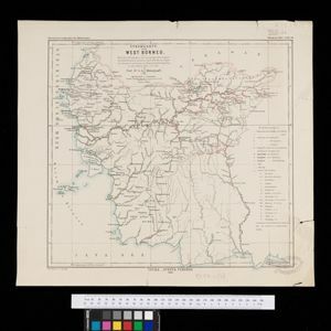
Stromkarte von West Borneo... mit Angabe der Stationen und Routen der Niederländischen Expedition in den Jahren 1893 und 1894
1895
Indonesia
The route of a late 19th century expedition by Dutch geologists, botanists, ethnographers and zoologists is marked on this map of southwest Borneo. Mountain peaks which were surveyed by the geologists are highlighted with a red circle.


Topographische kaart der residentie Soerabaja
1895
Indonesia
The residency of Soerabaja, East Java, featuring crops (coffee, coconut, sugarcane, rice, alang-alang, bamboo) and fishing ponds. Three inset maps: a triangulation map; a map of distances between settlements by types of transport; Bawean Island.

Stanford's Map of the Empires of China & Japan with the adjacent parts of the Russian Empire, India, Burma &c.
1895
Myanmar, Vietnam
The most northern part of Southeast Asia is shown on this map of China and Japan, with Burma (Myanmar) and Tong King (Vietnam) appearing at the bottom of the map. Mountains, rivers and settlements are marked, as well as a railway line in Burma.


Plan of the town and suburbs of Rangoon
c.1895-1897
Myanmar
Detailed plan of the city of Rangoon (Yangon, Myanmar) with commercial, religious, government and military buildings, surrounded by lakes, fields of crops and villages. Someone has drawn details on the map of areas that have undergone ‘levelling’.


The chief passes from Siam into Tavoi / The Siamese Malay States
1895
Myanmar, Thailand, Malaysia
Two maps of Siam (Thailand). The larger map shows routes through mountain passes from Siam to the city of Tavoi (Dawei, on the west coast of Myanmar). The smaller map is marked with trade routes around Lower Siam (Southern Thailand).

Topographische kaart van het eiland Billiton: vluchtig opgenomen in de jaren 1877-1878
1894
Indonesia
This map of the island of Billiton (Belitung, Indonesia) features mountains, rivers, railways, roads, settlements, coconut plantations and administrative borders. An inset map shows the island’s port and capital city Tanjung Pandan.
- Filter from 1478 to 1900
- Indonesia767
- Malaysia525
- Myanmar503
- Thailand485
- Singapore462
- Vietnam445
- Cambodia436
- Laos414
- Brunei413
- Philippines395
- East Timor350
- Southeast Asia343
- more Simple Location »
- Sumatra514
- Java495
- Borneo464
- Malay Peninsula402
- Sulawesi356
- Celebes292
- Dutch East Indies265
- Siam264
- Western New Guinea241
- Maluku Islands232
- Sunda Islands192
- Pegu181
- more Detailed Location »
- Port70
- Railway Station33
- Pier17
- [remove]River941
- Road247
- Path154
- Railway/Tramway112
- Postal Route80
- Telegraph/Telephone35
- Canal32
- Bridge22
- Legend365
- Cartouche279
- Inset Map220
- Illustration211
- Elevation87
- Coat of Arms77
- [remove]Longitude and Latitude941
- Scale694
- Contour Lines/Elevation410
- Written Note/Details229
- Compass Rose221
- Rhumbline Network48


