
Search Results


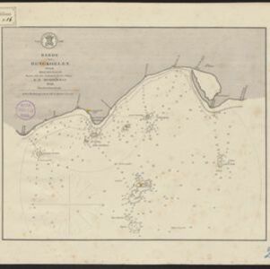
Sumatra: Residentie Benkoelen (Bengkoelen)
c.1894-1895
Indonesia
Map of the residency of Benkoelen (Bengkulu, southwest coast of Sumatra), over 10 sheets, with an inset map of the city of Bengkoelen (Bengkulu). Types of crops—coconut, rice, alang-alang, nipah palm, coffee—are marked. Sheet number 8 is missing.

Kaart van het middengedeelte van Sumatra
1890
Indonesia
Details of each area’s resources are printed on this map of Sumatra: rattan, coffee, pepper, Chinese cinnamon, tobacco, resins, camphor, cotton, coal, gold, lumber, elephants, horses, as well as the locals’ ethnicity (Malays, Javanese, Acehnese).

Topographische en geologische kaart van Zuid-Sumatra bevattende de residentien Bengkoelen, Palembang en Lampongsche Districten
1880
Indonesia
A topographical and geological map of southern Sumatra, over four sheets. Areas of igneous and sedimentary rock, coal, fossils, petroleum, active volcanoes and hot springs are marked, along with mountains, rivers and marshland, roads and settlements.

Kaart van de Adsistent Residentie Benkoelen en van de Eilanden Bewesten Sumatra
1860
Indonesia
Map of part of the Dutch colonial administrative region (assistant residency) of Benkoelen (Bengkulu, Sumatra), with an inset map of the Mentawai Islands. (From ‘Algemeene Atlas van Nederlandsche Indie [General Atlas of the Dutch East Indies]’.)

Kaart van de Adsistent Residentie Benkoelen: Middendeel
1860
Indonesia
Map of part of the Dutch colonial administrative region (assistant residency) of Benkoelen (Bengkulu, Sumatra). Inset map of Nias Island and the Batu Islands. (From ‘Algemeene Atlas van Nederlandsche Indie [General Atlas of the Dutch East Indies]’.)

Kaart van de Adsistent Residentie Benkoelen: Noorderdeel
1860
Indonesia
Map of part of the Dutch colonial administrative region (assistant residency) of Benkoelen (Bengkulu, Sumatra). There is an inset map of the Banyak Islands. (From ‘Algemeene Atlas van Nederlandsche Indie [General Atlas of the Dutch East Indies]’.)

- Filter from 1856 to 1898
- [remove]Dutch9
- [remove]Longitude and Latitude9
- Contour Lines/Elevation7
- Scale5
- Compass Rose3


