
Search Results
12 Results found


Atlas van Nederlandsch Oost-Indië
c.1897-1904
Indonesia
Very detailed atlas of the entire Dutch East Indies, over 16 map sheets, with a cover and overview map. Includes topographic maps, inset maps of cities and islands, and maps featuring land and sea routes, languages, geology, colonial territory etc.


Topographische kaart van het eiland Billiton: vluchtig opgenomen in de jaren 1877-1878
1894
Indonesia
This map of the island of Billiton (Belitung, Indonesia) features mountains, rivers, railways, roads, settlements, coconut plantations and administrative borders. An inset map shows the island’s port and capital city Tanjung Pandan.

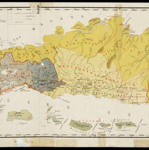
Kaart van de dichtheid van bevolking van Java en Madoera
1892
Indonesia
This map shows the population density of Java and Madura in 1892. The area is divided into regencies, which are then subdivided into districts, with the districts shaded to represent its population. Each district is also listed under its regency.

Kaart van een gedeelte van Borneo: met aanwijzing van de grens tusschen het Nederlandsch gebied en dat van het Britsche Protectoraat
1891
Indonesia, Malaysia, Myanmar
Map marking the border (in orange) agreed between British and Dutch territory on Borneo in 1891. Alternative borders are shown: according to the Dutch (blue), according to the British North Borneo Society (yellow) and proposed by the British (green).

Kaart van een gedeelte van Borneo: met aanwijzing van de grens tusschen het Nederlandsch gebied en dat van het Britsche Protectoraat
1891
Indonesia, Malaysia
Map marking the border (in orange) agreed between British and Dutch territory on Borneo in 1891. Alternative borders are shown: according to the Dutch (blue), according to the British North Borneo Society (yellow) and proposed by the British (green).
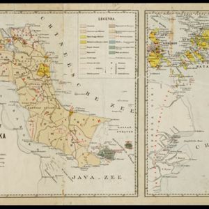
Schets-taalkaart van de residentie Bangka / Schets-taalkaart van den Riouw- en Lingga-archipel
1889
Indonesia
Two separate maps showing the languages and dialects spoken on the islands of Bangka, and the Riouw (Riau) and Lingga archipelagos, in the late 19th century. On Bangka alone, there are 12 languages or dialects listed.

Kaart van een gedeelte van Nieuw-Guinea bevattende het Nederlandsche- en de aangrenzende deelen van het Britsche- en het Duitsche gebied
1884
Indonesia, Papua New Guinea
Map showing the results of an 1884 agreement between the Netherlands and Britain to exchange parts of their colonial territories in New Guinea: the red area was ceded by the Netherlands to Britain; green was ceded by Britain to the Netherlands.
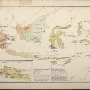
Kaart aangevende den bestaande toestand met betrekking tot het rechtswezen in Ned. Indië
1883
Indonesia
This map highlights the judicial system in the Dutch East Indies (‘Nederlands-Indië’) in the late 19th century. Different colours indicate the areas of authority of the different courts of law. There is an inset map of Java.
- [remove]Longitude and Latitude12
- Scale12
- Contour Lines/Elevation6
- Written Note/Details4
- [remove]Topographische Inrichting12
- Topographische Bureau2
- Departement van Koloniën1


