
Search Results

Kaart van de Karo landen (Oost Sumatra)
1891
Indonesia
A map recording five Dutch expeditions through the Karo Lands of northern Sumatra. The mountainous terrain is represented by contour lines, with peaks’ heights marked. The names of groups of the indigenous Karo people are shown in large letters.


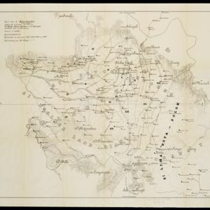
Kaart van het gebied bezet in Groot-Atjeh
1891
Indonesia
A map of Groot-Atjceh and the city of Kota Radja (modern Banda Aceh) at the northern tip of Sumatra, detailing routes (rivers, roads, railways), crops (rice, banana, sugarcane, betel, reed, alang-alang, bamboo) and land features (forests, wetlands).


Kaart der Bataklanden en van het eiland Nijas
1890
Indonesia
A large-scale map of northern Sumatra, spread over 16 sheets, and divided into administrative regions. The island of Nijas (Nias) is marked with the locations of local tribes, and there is a list of other maps referenced in producing the map.

Kaart van Zuid Celebes met uitzondering van het rijk Gowa
1890
Indonesia
Detailed topographical map of South Celebes (Sulawesi) spread over four sheets, featuring crops (coffee, alang-alang, rice), fishing ponds, salt panning. With two additional maps of the island of Saleijer (Selayar) and Pitoempanoewae (Pitumpanua).

Kaart der Bataklanden en van het eiland Nijas
1890
Indonesia
A large-scale map of northern Sumatra, spread over 16 sheets, and divided into administrative regions. The island of Nijas (Nias) is marked with the locations of local tribes, and there is a list of other maps referenced in producing the map.

Topographische Kaart der residentie Bagelen
1890
Indonesia
The residency of Bagelen, Central Java, is shown divided into regencies and districts. Coffee, tea and cinnamon plantations, fields of rice, alang-alang and other crops, mountains, rivers, hot and mineral springs, settlements and routes are marked.

Kaart van de residentie Oostkust van Sumatra
1889
Indonesia
Detailed topographical map of the east coast of Sumatra, spread over 34 sheets. The area’s farms are listed and shown on the map, with types of crop grown. With five inset maps of individual towns. Two sheets and the cover sheet are missing.

Kaart van de residentie Oostkust van Sumatra
1889
Indonesia
Detailed topographical map of the east coast of Sumatra, spread over 36 sheets plus a cover sheet of the whole area. Mountains and forests dominate, with villages, routes and administrative borders shown. With five inset maps of individual towns.
- Filter from 1686 to 1899
- [remove]Longitude and Latitude167
- Scale150
- Contour Lines/Elevation147
- Written Note/Details38
- Compass Rose18
- Rhumbline Network2


