
Search Results


Plan of the town and suburbs of Rangoon
c.1895-1897
Myanmar
Detailed plan of the city of Rangoon (Yangon, Myanmar) with commercial, religious, government and military buildings, surrounded by lakes, fields of crops and villages. Someone has drawn details on the map of areas that have undergone ‘levelling’.

The chief passes from Siam into Tavoi / The Siamese Malay States
1895
Myanmar, Thailand, Malaysia
Two maps of Siam (Thailand). The larger map shows routes through mountain passes from Siam to the city of Tavoi (Dawei, on the west coast of Myanmar). The smaller map is marked with trade routes around Lower Siam (Southern Thailand).


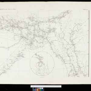
Map to illustrate Convention of March 1st 1894 between Great Britain and China: From the Map of Upper Burma
1894
Myanmar
Map of the border region between the Shan States of northeast Burma (Myanmar) and China's Yunnan Province, illustrating the result of the 1894 Sino-British boundary convention. The Burma side is more detailed, with mountains, rivers and settlements.


A map of British North Borneo
1894
Malaysia, Brunei, Indonesia
The colonial territories of British North Borneo are shown in pink on this late 19th century map, with Brunei and Sarawak in green, and Dutch colonial territory in yellow. Sea routes around the British Empire are depicted on an inset map.


- Filter from 1598 to 1900
- Myanmar240
- Indonesia211
- Malaysia207
- Thailand207
- Singapore171
- Vietnam171
- Cambodia165
- Laos156
- Brunei146
- Philippines145
- East Timor128
- Southeast Asia126
- more Simple Location »
- [remove]Longitude and Latitude356
- Scale249
- Contour Lines/Elevation128
- Written Note/Details101
- Compass Rose84
- Rhumbline Network34


