
Search Results
3 Results found
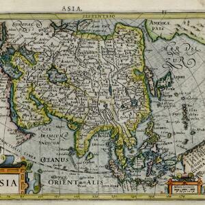
Asia
c.1609-1621
Brunei, Cambodia, East Timor, Indonesia, Laos, Malaysia, Myanmar, Philippines, Singapore, Southeast Asia, Thailand, Vietnam
This early 17th century map of Asia by Jodocus Hondius was based on the earlier work of the Gerard Mercator. Hondius republished Mercator’s ‘Atlas’, with additional maps, which was instrumental in re-establishing Mercator’s reputation.

Descriptio hydrographica accommodata ad battavorum navagatione in Javam insulam Indiæ Orientalis
c.1599-1628
Brunei, Cambodia, East Timor, Indonesia, Laos, Malaysia, Myanmar, Philippines, Singapore, Southeast Asia, Thailand, Vietnam
This map shows the route of the first Dutch expedition to Southeast Asia in 1595-7. Led by Cornelis de Houtman, it was an attempt to enter the spice trade. The route crosses east over the Indian Ocean, circles the island of Java, and returns west.
- [remove]Longitude and Latitude3
- Compass Rose1
- Rhumbline Network1
- Scale1
- Written Note/Details1


