
Search Results
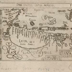

Descriptio hydrographica accommodata ad battavorum navagatione in Javam insulam Indiæ Orientalis
c.1599-1628
Brunei, Cambodia, East Timor, Indonesia, Laos, Malaysia, Myanmar, Philippines, Singapore, Southeast Asia, Thailand, Vietnam
This map shows the route of the first Dutch expedition to Southeast Asia in 1595-7. Led by Cornelis de Houtman, it was an attempt to enter the spice trade. The route crosses east over the Indian Ocean, circles the island of Java, and returns west.

Descriptio hydrographica accommodata ad battavorum navagatione in Javam insulam Indiæ Orientalis
1601
Brunei, Cambodia, East Timor, Indonesia, Laos, Malaysia, Myanmar, Philippines, Singapore, Southeast Asia, Thailand, Vietnam
This map shows the route of the first Dutch expedition to Southeast Asia in 1595-7. Led by Cornelis de Houtman, it was an attempt to enter the spice trade. The route crosses east over the Indian Ocean, circles the island of Java, and returns west.
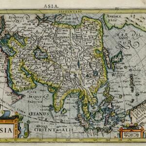
Asia
c.1609-1621
Brunei, Cambodia, East Timor, Indonesia, Laos, Malaysia, Myanmar, Philippines, Singapore, Southeast Asia, Thailand, Vietnam
This early 17th century map of Asia by Jodocus Hondius was based on the earlier work of the Gerard Mercator. Hondius republished Mercator’s ‘Atlas’, with additional maps, which was instrumental in re-establishing Mercator’s reputation.

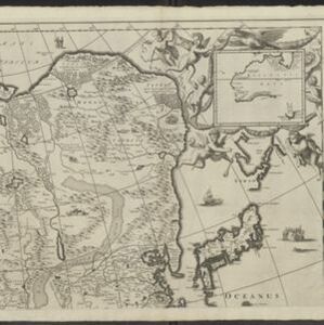
Asia
1690
Brunei, Cambodia, East Timor, Indonesia, Laos, Malaysia, Myanmar, Papua New Guinea, Philippines, Singapore, Southeast Asia, Thailand, Vietnam
Three sheets of a late 17th century map of Asia, with Southeast Asia on the third sheet. The oceans are decorated with drawings of sailing ships, and there is a detailed scene of Asian merchants, including a chained and kneeling slave and a camel.

Charte von Ost-Indien und den angroentzenden Laendern
1737
Brunei, Cambodia, East Timor, Indonesia, Laos, Malaysia, Myanmar, Philippines, Singapore, Southeast Asia, Thailand, Vietnam
The London-based cartographer Herman Moll (1654?–1732) created this map of Asia in the early 18th century. There are five insets showing Asian trading cities, including of the ports of Batavia (Jakarta) and Bantam (Banten) in western Java.

Karte von dem eylande Sumatra nach den tagebüchern der schiffer
1764
Malaysia, Indonesia, Singapore
The title of this mid-18th century map of Sumatra and the Malay Peninsula claims that it was based on the diaries of sailors. Interestingly, the title is repeated in both German and French, as are the names of some of the locations marked on the map.
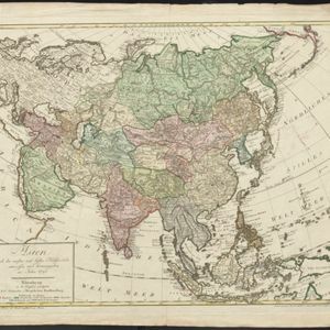
Asien nach den neusten und besten Hülfsmitteln entworffen und herausgegeben im Jahre 1793
1793
Brunei, Cambodia, East Timor, Indonesia, Laos, Malaysia, Myanmar, Papua New Guinea, Philippines, Singapore, Southeast Asia, Thailand, Vietnam
On this map of Asia, borders are outlined and cities underlined in different colours to show the colonial territories of the European powers: e.g. at this time, Benkulen (Bencoolen) on the west coast of Sumatra is British, and Malacca is Dutch.

Charte von Asien: nach den bewährtesten astronomischen Beobachtungen, den neuesten Reisen, und den vorzüglichsten Charten, insonderheit aber der Geographie des Hrn I.C. Gatterers gemäss
1793
Brunei, Cambodia, East Timor, Indonesia, Laos, Malaysia, Myanmar, Papua New Guinea, Philippines, Singapore, Southeast Asia, Thailand, Vietnam
Map of Asia, with mainland Southeast Asia in red and divided into ancient kingdoms, Sunda Islands in yellow, and the Philippines in grey. Twelve different scales are shown, as different countries used different measurement systems.
- Filter from 1590 to 1899
- [remove]Longitude and Latitude100
- Scale74
- Contour Lines/Elevation58
- Written Note/Details13
- Compass Rose12
- Rhumbline Network2


