
Search Results


China
1898
Brunei, Cambodia, East Timor, Indonesia, Laos, Malaysia, Myanmar, Philippines, Singapore, Southeast Asia, Thailand, Vietnam
This map highlights the colonisation of Southeast Asia, showing French Indochina (green), British Burma and Malaya (orange), the Dutch East Indies (pink), and the Spanish Philippines (green). In the region, only Siam (yellow) is independent.

Reduzirte Karte von den Philippinen und den Sulu Inseln
1884
Philippines, Malaysia, Indonesia
Maritime map of the Philippines, with inset maps of bays showing bathymetry (sea depth), shoals, reefs and anchor points. There is also an inset map of Taal Volcano, and elevations (side views of terrestrial landmarks like mountains and islands).

Mer des Indes: cartes de la direction et de l'intensité probables des vents
1880
Brunei, Cambodia, Indonesia, Malaysia, Myanmar, Philippines, Thailand, Vietnam, Singapore
A series of four maps of the Indian Ocean—one for each quarter of the calendar year—showing the direction and intensity of the winds, including around the seas of Southeast Asia. There are extensive explanatory notes.
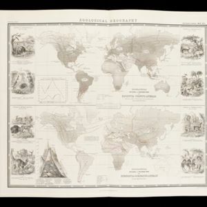
Zoological Geography: Sheet No. 3
1849
Brunei, Cambodia, East Timor, Indonesia, Laos, Malaysia, Myanmar, Papua New Guinea, Philippines, Singapore, Southeast Asia, Thailand, Vietnam
Two maps showing the distribution of rodent and ruminant animal species, including in Southeast Asia. Lines show the geographical range of individual species, alongside illustrations of the animals featured.
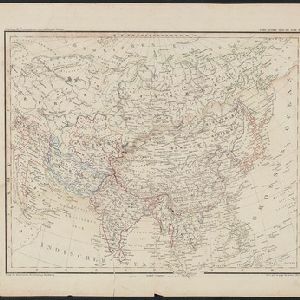
Übersichtskarte der Asiatischen Staaten
1845
Brunei, Cambodia, Indonesia, Laos, Malaysia, Myanmar, Philippines, Singapore, Southeast Asia, Thailand, Vietnam
This map of Asia is from the mid-19th century ‘Grosser Atlas der Erde [Great Atlas of the Earth]’ by the German publisher Albrecht Platt. It shows part of Southeast Asia, including the region’s borders with India and China.
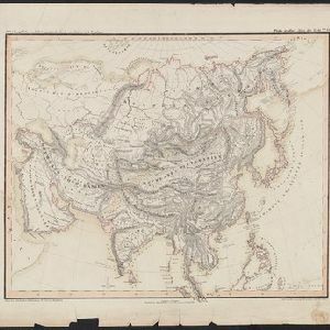
Oro- und hydrographische Karte von Asien nach Berghaus
1845
Brunei, Cambodia, Indonesia, Laos, Malaysia, Myanmar, Philippines, Singapore, Southeast Asia, Thailand, Vietnam
This title of this map refers to orography (which is shown in the use of hachures, short lines/dashes that give a sense of the shape and steepness of terrain) and hydrography (which is shown in the highlighting of coastal regions, shoals and reefs).

Reduzirte Karte von den Philippinen und den Sulu Inseln
1832
Malaysia, Indonesia, Philippines
Maritime map of the Philippines, with inset maps of bays showing bathymetry (sea depth), shoals, reefs and anchor points. There is also an inset map of Taal Volcano, and elevations (side views of terrestrial landmarks like mountains and islands).


A new chart of the Oriental Seas and Islands... from the Isle of Ceylon to Amoye in China
1790
Brunei, Cambodia, East Timor, Indonesia, Laos, Malaysia, Myanmar, Philippines, Singapore, Southeast Asia, Thailand, Vietnam
A late 18th century maritime map of Southeast Asia, marked with expedition routes including the return of Captain Cook’s HMS Endeavour from Australia in 1770, and Captain Philip Carteret’s circumnavigation expedition in 1768.

Isles Philippines et Moluques
1749
Indonesia, Philippines, Papua New Guinea, East Timor
From the second edition (1749) of ‘Atlas Portatif Universel et Militaire’ by the French cartographer Gilles Robert de Vaugondy (1688–1766), this map features the Philippines (in blue) and Maluku Islands (in red).
- Filter from 1599 to 1899
- [remove]Longitude and Latitude53
- Scale33
- Compass Rose20
- Written Note/Details13
- Rhumbline Network12
- Contour Lines/Elevation3


