Search

Search Results

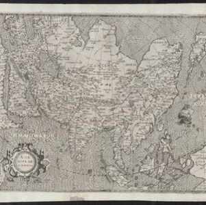
Tabula geograph in qua Europae, Africae, Asiaeq et circujacentium insularum orae maritimae accurate describuntur et ad jntelligentia navigationum Indicaru accommodantur

event1614

location_onBrunei, Cambodia, East Timor, Indonesia, Laos, Malaysia, Myanmar, Vietnam, Thailand, Southeast Asia, Singapore, Philippines

A map decorated with drawings of indigenous people, including from Southeast Asia: a Moluccan soldier with a helmet, sword and shield; a Javanese warrior with a spear and shield; a Sumatran woman holding a flower; and a Malaccan man with a sword.

Asiæ Nova Descriptio Auctore Jodoco Hondio

eventc.1613-1619

location_onBrunei, Cambodia, East Timor, Indonesia, Laos, Malaysia, Myanmar, Philippines, Singapore, Southeast Asia, Thailand, Vietnam

An early 17th century map by the Flemish/Dutch cartographer Jodocus Hondius showing Asia and part of Europe and Africa. The Latin text on New Guinea translates as ‘Whether it is an island or the southern part of the continent is not yet certain’.

Asiæ Nova Descriptio Auctore Jodoco Hondio

eventc.1613-1616

location_onBrunei, Cambodia, East Timor, Indonesia, Laos, Malaysia, Myanmar, Philippines, Singapore, Southeast Asia, Thailand, Vietnam

An early 17th century map by the Flemish/Dutch cartographer Jodocus Hondius showing Asia and part of Europe and Africa. The Latin text on New Guinea translates as ‘Whether it is an island or the southern part of the continent is not yet certain’.

Insulæ Indiæ orientalis præcipuæ: in quibus Moluccæ celeberrimæ sunt

event1606

location_onBrunei, Cambodia, East Timor, Indonesia, Laos, Malaysia, Myanmar, Philippines, Singapore, Southeast Asia, Thailand, Vietnam

On the right of this map, Latin text held within an elaborate border notes that five of the Maluku Islands are located nearby—Ternate, Tidore, Moti, Makian and Bacan—which trade spices including clove, cinnamon, nutmeg and ginger to the world.

Asiae nova descriptio

event1602

location_onBrunei, Cambodia, East Timor, Indonesia, Laos, Malaysia, Myanmar, Philippines, Singapore, Southeast Asia, Thailand, Vietnam

This early 17th century map by Jodocus Hondius features a number of mythical lakes that were once thought to exist in southern China—including ‘Cayamay Lacus’—and which feed several rivers that flow south through mainland Southeast Asia.

Moluccæ insulæ

event1602

location_onIndonesia

This early 17th century map features Gilolo (Halmahera) and Seram, as well as Celebes (Sulawesi). French text on the reverse describes the ‘Isles Molucques’ (Maluku Islands), including trade in nutmeg, mace, aloe, cinnamon, ginger, pepper and cloves.

Descriptio hydrographica accommodata ad battavorum navagatione in Javam insulam Indiæ Orientalis

event1601

location_onBrunei, Cambodia, East Timor, Indonesia, Laos, Malaysia, Myanmar, Philippines, Singapore, Southeast Asia, Thailand, Vietnam

This map shows the route of the first Dutch expedition to Southeast Asia in 1595-7. Led by Cornelis de Houtman, it was an attempt to enter the spice trade. The route crosses east over the Indian Ocean, circles the island of Java, and returns west.

Descriptio hydrographica accommodata ad battavorum navagatione in Javam insulam Indiæ Orientalis

eventc.1599-1628

location_onBrunei, Cambodia, East Timor, Indonesia, Laos, Malaysia, Myanmar, Philippines, Singapore, Southeast Asia, Thailand, Vietnam

This map shows the route of the first Dutch expedition to Southeast Asia in 1595-7. Led by Cornelis de Houtman, it was an attempt to enter the spice trade. The route crosses east over the Indian Ocean, circles the island of Java, and returns west.

Exacta & accurata delineatio cum orarum maritimarum tum etiam locorum terrestrium quae in regionibus China, Cauchinchina, Camboia sive Champa, Syao, Malacca, Aracan & Pegu

event1598

location_onBrunei, Cambodia, East Timor, Indonesia, Laos, Malaysia, Myanmar, Philippines, Singapore, Southeast Asia, Thailand, Vietnam

Unusually, north is located to the left of this map of East Asia, rather than the top. The text notes that shallows and reefs are marked, and that the map is based on the explorations of Portuguese ships. Illustrations include sea monsters and ships.

Insvlae Molvccae

event1598

location_onBrunei, Cambodia, East Timor, Indonesia, Laos, Malaysia, Papua New Guinea, Philippines, Singapore, Southeast Asia, Thailand, Vietnam

A map featuring drawings of plants used to make spices in the Moluccas or Spice Islands: Nux Myristica (nutmeg), Cariophilorum arbor (cloves), Santalum flavum (yellow sandalwood), Santalum rubrum (red sandalwood), Santalum album (Indian sandalwood).

Indiae Orientalis insularumque adiacientium typus

event1598

location_onBrunei, Cambodia, East Timor, Indonesia, Laos, Malaysia, Myanmar, Philippines, Singapore, Southeast Asia, Thailand, Vietnam

A white banner at the right features text that notes that the ‘Insule Molucce’ (Maluku Islands) are famous for their abundance of spices, which are sold across the world. There are also Illustrations of mermaids and sea monsters wrecking a ship.

Asia

event1598

location_onBrunei, Cambodia, East Timor, Indonesia, Laos, Malaysia, Myanmar, Philippines, Singapore, Southeast Asia, Thailand, Vietnam

This late 16th century map features a 'wind-head', a decorative feature consisting of a drawing of the head of a human blowing to indicate wind.

close