
Search Results


Topographische kaart der residentie Krawang
1877
Indonesia
The residency of Krawang (Karawang), West Java, featuring plantations (coffee, coconut, cinnamon, nutmeg, sugar); crops (rice, alang-alang, bamboo); post offices, routes (road, postal, canals), administrative borders; mountains, rivers, forests.


Topographische kaart der residentie Semarang
c.1869-1871
Indonesia
The residency of Semarang, Central Java, featuring crops (coffee, rice, bamboo, nipa palm); warehouses, cemeteries, post offices; routes, administrative borders; mountains, rivers, forests. An inset map shows updated details of the Kendal district.

Topographische kaart der residentie Pekalongan
1870
Indonesia
Topographic map of the residency of Pekalongan (Central Java), divided into regencies (pink borders) and districts (yellow borders). Mountains, forests, settlements, routes, crops—alang-alang, coffee, sugar, rice—factories and warehouses are shown.
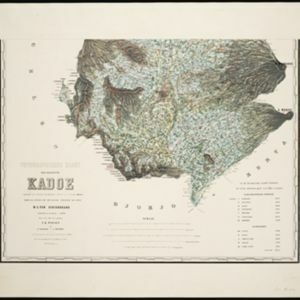
Topographische kaart der residentie Kadoe
1870
Indonesia
The residency of Kadoe (Kadu), Central Java, is shown divided into regencies and districts, with population figures for each district. Villages (kampongs) and towns, fields, mountains, rivers and roads are marked. There is an inset triangulation map.

Topographische kaart der residentie Japara
1870
Indonesia
Four-sheet topographic map of the residency of Japara (Jepara, Central Java), with an inset signal map of locations’ heights and distances. Administrative districts, crops—coffee, alang-alang, rice, sugarcane, coconut—and fishing ponds are shown.

Topographische kaart der residentie Djokjakarta
1870
Indonesia
The residency of Djokjakarta (Yogyakarta), southern Java, featuring crops (coffee, sugar, rice, alang-alang, tobacco, indigo plants, nipa palm, bamboo); warehouses, cemeteries, post offices; routes, administrative borders; mountains, rivers.


- Filter from 1839 to 1899
- [remove]Dutch East Indies100
- Java60
- Celebes23
- Sulawesi23
- Sumatra23
- Borneo14
- South China Sea10
- Madura9
- Maluku Islands9
- Makassar8
- Makasser8
- Malay Peninsula8
- more Detailed Location »
- [remove]Longitude and Latitude100
- Scale96
- Contour Lines/Elevation85
- Compass Rose30
- Written Note/Details21


