
Search Results


Kaart van Nederlandsch-Indie
1893
Brunei, Cambodia, Indonesia, Malaysia, Singapore, Thailand, Vietnam, East Timor, Philippines, Southeast Asia
Shipping routes are the focus of this map of the Dutch East Indies, indicated by red lines labelled with the name of the shipping company and the destinations. Parcel shipping routes are also shown. Inset maps feature railway lines too.

Kaart van de dichtheid van bevolking van Java en Madoera
1892
Indonesia
This map shows the population density of Java and Madura in 1892. The area is divided into regencies, which are then subdivided into districts, with the districts shaded to represent its population. Each district is also listed under its regency.

Kaart van den gemiddelden regenval op Java, tevens situatie-schets van de djati- en wildhoutbosschen
1892
Indonesia
This late 19th century map records the average rainfall at a variety of locations—marked with blue dots—on Java. Three types of forest are also shown: cultivated forest, wild forest under management, and wild forest not under management.

Kaart van den op Java en Madoera reeds in gebruik genomen grond
1892
Indonesia
Land usage statistics are shown on this map of Java and Madura. The amount of land used in each district is indicated by green hash marks, and by a number giving its land use percentage. District names are listed and identified by a letter.

Topographische kaart der residentie Djokjakarta
1892
Indonesia
The residency of Djokjakarta (Yogyakarta), southern Java, featuring crops (coffee, sugar, rice, alang-alang, tobacco, indigo plants, nipa palm, bamboo); warehouses, cemeteries, post offices; routes, administrative borders; mountains, rivers.

Topographische Kaart der residentie Pekalongan
1892
Indonesia
Topographic map of the residency of Pekalongan (Central Java), divided into regencies (pink borders) and districts (yellow borders). Mountains, forests, settlements, routes, crops—alang-alang, coffee, sugar, rice—factories and warehouses are shown.


Kaart van den Indischen-Archipel, Aanwijzende de standplaatsen der Europeesche ambtenaren bij het Binnenlansch Bestuur
1891
Indonesia
This map of the Dutch East Indies uses colour to demarcate government administrative areas (residencies or provinces), with red dots/flags indicating the locations of various levels of government officials. With inset maps of west Sumatra and Java.

Kaart van een gedeelte van Borneo: met aanwijzing van de grens tusschen het Nederlandsch gebied en dat van het Britsche Protectoraat
1891
Indonesia, Malaysia, Myanmar
Map marking the border (in orange) agreed between British and Dutch territory on Borneo in 1891. Alternative borders are shown: according to the Dutch (blue), according to the British North Borneo Society (yellow) and proposed by the British (green).
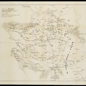
Kaart van de Karo landen (Oost Sumatra)
1891
Indonesia
A map recording five Dutch expeditions through the Karo Lands of northern Sumatra. The mountainous terrain is represented by contour lines, with peaks’ heights marked. The names of groups of the indigenous Karo people are shown in large letters.

- Filter from 1700 to 1900
- [remove]Dutch East Indies329
- Java165
- Sumatra120
- Borneo82
- Sulawesi75
- Celebes72
- Java Sea54
- Malay Peninsula45
- Maluku Islands40
- Western New Guinea39
- South China Sea37
- Celebes Sea26
- more Detailed Location »
- [remove]Longitude and Latitude329
- Scale266
- Contour Lines/Elevation262
- Written Note/Details85
- Compass Rose50
- Rhumbline Network2


