
Search Results


Asiatic archipelago
1876
Vietnam, Myanmar, Papua New Guinea, Philippines, Singapore, Southeast Asia, Thailand, Malaysia, Laos, Indonesia, East Timor, Cambodia, Brunei
This late 19th century map of Southeast Asia shows the best maritime routes around the region, according to the time of year. There are also inset maps highlighting the rivers and southern islands of Singapore, and the sea depth around Labuan Island.

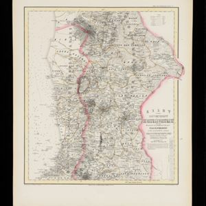
Western part of the Java Sea : from Lucipara I. to Sunda Strait and Batavia
1866
Indonesia
Designed to aid navigation around the western Java Sea, this map features bathymetry (sea depth), current and tide data, and is marked with shoals, reefs and other hazards. Written notes add details at specific locations (e.g. ‘heavy tide rips’).

Chart of the China Sea
1864
Papua New Guinea, Indonesia, Malaysia, Cambodia, East Timor, Philippines, Singapore, Thailand, Vietnam
To aid navigation, this map shows small islands, shoals and reefs, maritime routes for use during monsoons or at particular times of the year, bathymetry (sea depth), tide information, shipwrecks, compass roses and landmark mountains at the coasts.

Kaart van de Oosterhelft der Residentie Palembang
1860
Indonesia
Map of the eastern half of the Dutch colonial administrative region (residency) of Palembang, Sumatra. A fort is marked in the town of Batoeradja. (From ‘Algemeene Atlas van Nederlandsche Indie [General Atlas of the Dutch East Indies]’.)

Kaart van de Residentie Riouw en Onderhoorigheden
1860
Indonesia, Singapore, Malaysia
Map of the Dutch colonial administrative region (residency) of Riouw (Riau) focusing on the islands and sea passages, with bathymetry (sea depth) marked. (From ‘Algemeene Atlas van Nederlandsche Indie [General Atlas of the Dutch East Indies]’.)

Zee- en landkaart waarop de dagelijksche vorderingen eener zeereis van Nederland naar N.O. Indië door een deskundig passagier naauwkeurig aangeteekend
c.1860
Brunei, Cambodia, East Timor, Indonesia, Laos, Malaysia, Myanmar, Philippines, Singapore, Southeast Asia, Thailand, Vietnam
Map of the Eastern Hemisphere featuring a maritime route from the Netherlands to the port of Batavia (Jakarta) in the East Indies, with each day’s progress marked. Other routes around the region and back to Europe via the Suez Canal are also shown.

Asiatic archipelago
1858
Vietnam, Myanmar, Papua New Guinea, Philippines, Singapore, Southeast Asia, Thailand, Malaysia, Laos, Indonesia, East Timor, Cambodia, Brunei
This late 19th century map of Southeast Asia shows the best maritime routes around the region, according to the time of year. There are also inset maps highlighting the rivers and southern islands of Singapore, and the sea depth around Labuan Island.

Kaart van de Gouvernement Sumatra's Westkust No. 1
1857
Indonesia
Map of part of the Dutch colonial administrative region of Sumatra’s Westkust (Sumatra’s West Coast). A route into the port of Sibogha (Sibolga) is marked. (From ‘Algemeene Atlas van Nederlandsche Indie [General Atlas of the Dutch East Indies]’.)

Kaart van de Gouvernement Sumatra's Westkust No. 2
1857
Indonesia
Map of part of the Dutch colonial administrative region of Sumatra’s Westkust (Sumatra’s West Coast). The sea is marked with bathymetry (sea depth). (From ‘Algemeene Atlas van Nederlandsche Indie [General Atlas of the Dutch East Indies]’.)
Kaart van de Gouvernement Sumatra's Westkust No. 3
1857
Indonesia
Map of part of the Dutch colonial administrative region of Sumatra’s Westkust (Sumatra’s West Coast). The sea is marked with bathymetry (sea depth). (From ‘Algemeene Atlas van Nederlandsche Indie [General Atlas of the Dutch East Indies]’.)
- Filter from 1599 to 1900
- [remove]Maritime Route116
- Bathymetry73
- Current Data12
- Tide Data10
- [remove]Longitude and Latitude116
- Scale65
- Compass Rose51
- Contour Lines/Elevation38
- Written Note/Details29
- Rhumbline Network25


