
Search Results
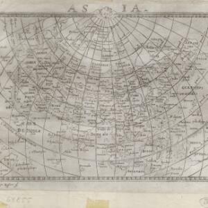

Asia partiṽ̃ orbis maxima MDXCVIII
1598
Brunei, Cambodia, East Timor, Indonesia, Laos, Malaysia, Myanmar, Philippines, Singapore, Southeast Asia, Thailand, Vietnam
The title of this late 16th century map of Asia translates from Latin as 'Asia the largest part of the world'. There is German text on the back of the map giving a description of Asia.
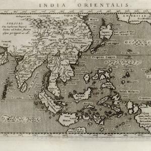
India orientalis
c.1597-1617
Brunei, Cambodia, East Timor, Indonesia, Laos, Malaysia, Myanmar, Philippines, Singapore, Southeast Asia, Thailand, Vietnam
Latin text written on New Guinea explains that it is uncertain whether it is an island or part of ‘Australis’ (‘southern land’) a name that was used for a continent thought to exist in the region (and after which Australia was eventually named).

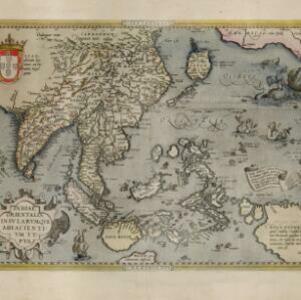
Exacta & accurata delineatio cùm orarum maritimarum tùm etiam locorum terrestrium quae in regionibus China, Cauchinchina, Camboia sive Champa, Syao, Malacca, Aracan & Pegu
1596
Brunei, Cambodia, East Timor, Indonesia, Laos, Malaysia, Myanmar, Philippines, Singapore, Southeast Asia, Thailand, Vietnam
Unusually, north is located to the left of this map of East Asia, rather than the top. The text notes that shallows and reefs are marked, and that the map is based on the explorations of Portuguese ships. Illustrations include sea monsters and ships.

Exacta & accurata delineatio cùm orarum maritimarum tùm etiam locorum terrestrium quae in regionibus China, Cauchinchina, Camboia sive Champa, Syao, Malacca, Aracan & Pegu
1595
Brunei, Cambodia, East Timor, Indonesia, Laos, Malaysia, Myanmar, Philippines, Singapore, Southeast Asia, Thailand, Vietnam
Unusually, north is located to the left of this map of East Asia, rather than the top. The text notes that shallows and reefs are marked, and that the map is based on the explorations of Portuguese ships. Illustrations include sea monsters and ships.
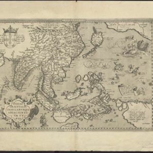
Indiae Orientalis insularumque adiacientium typus
c.1595-1601
Brunei, Cambodia, East Timor, Indonesia, Laos, Malaysia, Myanmar, Philippines, Singapore, Southeast Asia, Thailand, Vietnam
A white banner at the right features text that notes that the ‘Insule Molucce’ (Maluku Islands) are famous for their abundance of spices, which are sold across the world. There are also Illustrations of mermaids and sea monsters wrecking a ship.
Indiae Orientalis insularumque adiacientium typus
c.1591-1592
Brunei, Cambodia, East Timor, Indonesia, Laos, Malaysia, Myanmar, Philippines, Singapore, Southeast Asia, Thailand, Vietnam
A banner at the right features text that notes that the ‘Insule Molucce’ (Maluku Islands) are famous for their abundance of spices, which are sold across the world. There are also Illustrations of mermaids and sea monsters wrecking a ship.
- Filter from 1565 to 1900
- [remove]East Timor537
- Indonesia536
- Malaysia511
- Brunei502
- Singapore501
- Philippines500
- Vietnam471
- Thailand467
- Cambodia465
- Southeast Asia465
- Laos449
- Myanmar449
- more Simple Location »
- Borneo496
- Sumatra493
- Java490
- Sulawesi461
- Celebes393
- Malay Peninsula382
- Western New Guinea322
- Maluku Islands316
- Siam246
- Sunda Islands231
- Malacca195
- Pegu195
- more Detailed Location »
- [remove]Longitude and Latitude537
- Scale290
- Compass Rose163
- Written Note/Details132
- Contour Lines/Elevation91
- Rhumbline Network44


