
Search Results

Oost-Indie
c.1867
Brunei, Cambodia, East Timor, Indonesia, Laos, Malaysia, Myanmar, Philippines, Singapore, Southeast Asia, Thailand, Vietnam
Map of the East Indies in the mid-19th century, with Dutch colonial territory (Dutch East Indies) coloured in brown. Dutch administrative regions—such as residencies (‘residentie’) and governorates (‘gouvernement’)—are labelled.

Chart of the China Sea
1864
Papua New Guinea, Indonesia, Malaysia, Cambodia, East Timor, Philippines, Singapore, Thailand, Vietnam
To aid navigation, this map shows small islands, shoals and reefs, maritime routes for use during monsoons or at particular times of the year, bathymetry (sea depth), tide information, shipwrecks, compass roses and landmark mountains at the coasts.

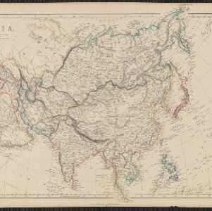
Stanford's library map of Asia
1862
Brunei, Cambodia, East Timor, Indonesia, Laos, Myanmar, Malaysia, Philippines, Singapore, Southeast Asia, Thailand, Vietnam
Map of Asia on four sheets, with Southeast Asia on sheet four. British colonial territory—British Burma, the Straits Settlements, Sarawak—is highlighted in red, with the Dutch East Indies, Spanish Philippines and Portuguese East Timor also shown.

Azië : 1861
1861
Brunei, Cambodia, East Timor, Indonesia, Laos, Malaysia, Myanmar, Papua New Guinea, Philippines, Singapore, Southeast Asia, Thailand, Vietnam
Map of Asia published by the North Holland Regional Association of the Dutch Teachers' Association. Mainland Southeast Asia is labelled ‘Achter Indie [Beyond India]’; the Indonesian Archipelago is labelled ‘Indische Archipel [Indian Archipelago]’.
Asia
1860
Papua New Guinea, Brunei, Cambodia, Indonesia, Laos, Malaysia, Myanmar, Philippines, Singapore, Southeast Asia, Thailand, Vietnam
This mid-19th century map of Asia has colour-coded borders that show the beginnings of the emergence of the modern nation states of Southeast Asia, such as Laos, Burmah (Burma), Siam (Thailand) and Malaya (Malaysia).

Zee- en landkaart waarop de dagelijksche vorderingen eener zeereis van Nederland naar N.O. Indië door een deskundig passagier naauwkeurig aangeteekend
c.1860
Brunei, Cambodia, East Timor, Indonesia, Laos, Malaysia, Myanmar, Philippines, Singapore, Southeast Asia, Thailand, Vietnam
Map of the Eastern Hemisphere featuring a maritime route from the Netherlands to the port of Batavia (Jakarta) in the East Indies, with each day’s progress marked. Other routes around the region and back to Europe via the Suez Canal are also shown.
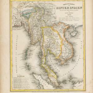
Neueste Karte von Hinter Indien
1860
Cambodia, Laos, Malaysia, Myanmar, Singapore, Thailand, Vietnam
The borders on this mid-19th century map of mainland Southeast Asia are colour-coded to show kingdoms, countries and colonial territories. Twelve different scales are shown, as different countries used different measurement systems.

Asiatic archipelago
1858
Vietnam, Myanmar, Papua New Guinea, Philippines, Singapore, Southeast Asia, Thailand, Malaysia, Laos, Indonesia, East Timor, Cambodia, Brunei
This late 19th century map of Southeast Asia shows the best maritime routes around the region, according to the time of year. There are also inset maps highlighting the rivers and southern islands of Singapore, and the sea depth around Labuan Island.

Ost-Indien mit den Inseln
1857
Cambodia, Brunei, East Timor, Indonesia, Laos, Malaysia, Myanmar, Philippines, Singapore, Southeast Asia, Thailand, Vietnam
On this map of India and Southeast Asia, borders are outlined and cities underlined in different colours to show the colonial territories of the European powers. Independent states such as Birma, Siam and Annam are also marked.
- Filter from 1478 to 1900
- Malaysia574
- [remove]Singapore574
- [remove]Thailand574
- Cambodia561
- Indonesia561
- Vietnam551
- Brunei534
- Myanmar533
- Laos525
- Philippines513
- Southeast Asia494
- East Timor466
- more Simple Location »
- Sumatra542
- Borneo515
- Java474
- Malay Peninsula427
- Sulawesi422
- Celebes359
- Siam300
- Western New Guinea295
- Maluku Islands278
- Sunda Islands230
- Pegu219
- Malacca208
- more Detailed Location »
- [remove]Longitude and Latitude574
- Scale323
- Compass Rose169
- Written Note/Details141
- Contour Lines/Elevation82
- Rhumbline Network39


