
Search Results


Stanford's Map of the Empires of China & Japan with the adjacent parts of the Russian Empire, India, Burma &c.
1896
Myanmar, Vietnam
The most northern part of Southeast Asia is shown on this map of China and Japan, with Burma (Myanmar) and Tong-King (Vietnam) appearing at the bottom of the map. Mountains, rivers and settlements are marked, as well as a railway line in Burma.

Route chart to India and the East
1895
Brunei, Cambodia, East Timor, Indonesia, Laos, Malaysia, Myanmar, Philippines, Singapore, Southeast Asia, Thailand, Vietnam
Map of Asia featuring steamship routes—including around Southeast Asia—connecting ports such as Penang, Singapore, Batavia (Jakarta), Saigon, Bangkok, Rangun (Yangon), Manila, Macassar (Makassar) etc. There is also an inset map of Singapore.

Stanford's Map of the Empires of China & Japan with the adjacent parts of the Russian Empire, India, Burma &c.
1895
Myanmar, Vietnam
The most northern part of Southeast Asia is shown on this map of China and Japan, with Burma (Myanmar) and Tong King (Vietnam) appearing at the bottom of the map. Mountains, rivers and settlements are marked, as well as a railway line in Burma.

Map of the Kingdom of Siam and its dependencies
1888
Cambodia, Laos, Malaysia, Myanmar, Thailand, Vietnam
Map of the Kingdom of Siam, featuring mountains, rivers and villages, and surrounded by a yellow border (the border with Upper Burma and China in the north is undefined). The southern part of Siam is shown on an inset map of the Malay Peninsula.
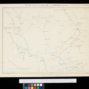
Sketch map to illustrate the Lang-son and Red River operations
1886
Vietnam
Map of the French military advance on the city of Lang-Son in February 1885 during the Sino-French War, and the following month’s humiliating retreat which brought an end to the war, and triggered the collapse of the French government.

Map of China, Tonquin and Cochin-China, with a chart extending from China to western Europe
1883
Cambodia, Laos, Thailand, Vietnam
Two maps, one of which features mainland Southeast Asia: Anam (Tonquin and Cochin China) in red, Lower Cochin China in green, Cambodia in yellow, and Siam in white. An inset map shows maritime routes between Europe and Asia.

Algemeene kaart van Nederlandsch Indië
1879
Cambodia, Indonesia, Papua New Guinea, East Timor, Southeast Asia, Thailand, Malaysia, Philippines, Laos, Vietnam, Singapore, Brunei, Myanmar
A late 19th century map of the Dutch East Indies on four sheets, detailing maritime routes around the region. There are also inset maps showing railways, rivers, roads, and telegraph systems, as well as individual islands and cities.

Übersichtskarte der Französischen Expedition in Hinterindien vom Me-khong bis zum Jang-tse-kiang
1869
Myanmar, Thailand, Vietnam, Laos
This map of the border region between China, Birma (Myanmar), Siam (Thailand and Laos) and Anam (Vietnam) is marked with the routes of five expeditions of the region from 1837 to 1868. Locations of Roman Catholic missionaries are also shown.

Malay Archipelago, or East India Islands
1851
Brunei, Cambodia, East Timor, Indonesia, Laos, Malaysia, Myanmar, Papua New Guinea, Philippines, Singapore, Southeast Asia, Thailand, Vietnam
This mid-19th century map of Southeast Asia is illustrated with drawings of indigenous people from New Guinea, a ‘bee bear’ (probably a sun bear), a sailboat in front of Victoria Mount in New Guinea, and a village and palm trees in Sarawak, Borneo.

S.E. Peninsula and Malaysia
1849
Brunei, Cambodia, East Timor, Indonesia, Laos, Malaysia, Myanmar, Papua New Guinea, Philippines, Singapore, Southeast Asia, Thailand, Vietnam
The colonial possessions of Britain, the Netherlands, Spain, Portugal and Denmark are shown on this mid-19th century map of Southeast Asia. There are inset maps of Penang Island and Singapore, and text describing the region’s colonial history.

Map of the River of Don-nai from Cape St. James to the city of Saigon
1820
Vietnam
A map to aid in the navigation of the rivers leading to Saigon (Ho Chi Minh City, Vietnam). Details include bathymetry (water depth), currents, and a side view (or ‘elevation’) of hills to use as a landmark. Tides are described in written remarks.
- [remove]Longitude and Latitude17
- Scale16
- Contour Lines/Elevation10
- Compass Rose4
- Written Note/Details4
- Rhumbline Network3


