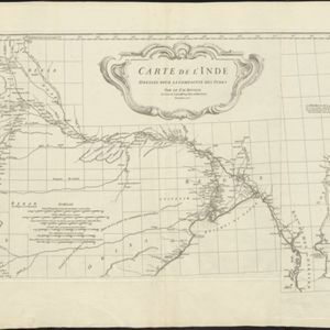
Carte de l'Inde: dressée pour la Compagnie des Indes
1752
Myanmar, Indonesia, Malaysia, Thailand
Spread over two sheets, this map of India also features the west coast of mainland Southeast Asia. There is also an inset map of the bay of Ashem (Banda Aceh, Sumatra), featuring bathymetry (sea depth), islands, shoals and reefs, and anchor points.