
Search Results
1321 Results found


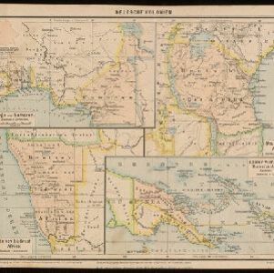
Map of Eastern New Guinea: illustrating a paper by Sir Wm. MacGregor
1897
Indonesia, Papua New Guinea
Map of eastern New Guinea, showing the routes—mainly along rivers—explored by Sir William MacGregor, the administrator of British New Guinea. The borders with the German colonial territory (Kaiser-Wilhelmsland) and Dutch New Guinea are also marked.

Queensland and British New Guinea
1897
Indonesia, Papua New Guinea
New Guinea is divided between British, German and Dutch colonial powers on this map of New Guinea and Australia. There is a line marking the boundary between the British and German spheres of influence. Bays and islands around the coast are named.
Deutsche Kolonien
c.1896-1900
Indonesia, Papua New Guinea
From Joseph Kürschner’s ‘Universal-Konversations-Lexikon’, this map of German colonies includes the island of New Guinea. Divided between Dutch, British and German colonies, the German territory is Kaiser-Wilhelmsland and the Bismarck Archipelago.


Oostkust: Aroe-Eilanden / Ankerplaats voor Watoelei en Koemoel
1896
Indonesia
Map of the east coast of the Aru Islands (Maluku Islands), with bathymetry (sea depth), tides and currents, shoals and other obstructions. An inset map shows the anchorage at islands off the coast, along with elevation views of the islands.

Ankerplaatsen en mondingen van rivieren op de Noord- en Oostkust van Sumatra: Blad I
1896
Indonesia
Eleven separate maps of bays and river mouths of Sumatra, including two bays on the island on Bras (Breueh Island), and the bay at Kota Radja (Banda Aceh). Bathymetry (sea depth), anchor points, reefs and shoals are marked, along with tide data.

Vaarwaters en ankerplaatsen op de oostkust der Aroe-eilanden
1896
Indonesia
Four navigation maps of the waterways and anchorages around the east coast of the Aru Islands (in the Maluku Islands, near New Guinea). Bathymetry (sea depth), shoals and other obstructions are shown, with trees and villages to use as landmarks.

Overzichtskaart der residentie Wester-afdeeling van Borneo
1896
Indonesia
Map of western Borneo, divided into administrative districts. Mountains and larger settlements are marked with their height. A flag indicates a military garrison. A list of the districts notes their type of local ruler (Sultan, Prince etc.).

Schetskaart van West-Seran (Vulgo Ceram) / Schetskaart van Oost- en Midden Seran
1896
Indonesia
Map of the island of Seram in the Maluku Islands, originally produced as two separate maps. Red lines show lines of communication of local people (referred to as ‘Alfoer’), with their tribe’s name. Muslim, Christian and Alfoer settlements are marked.
- Filter from 1478 to 1900
- Indonesia1,105
- Malaysia752
- Myanmar688
- Thailand676
- Singapore664
- Vietnam628
- Cambodia620
- Brunei601
- Philippines585
- Laos570
- East Timor537
- Southeast Asia502
- more Simple Location »
- Port122
- Railway Station40
- Pier29
- River941
- Road268
- Path163
- Railway/Tramway130
- Postal Route91
- Telegraph/Telephone47
- Canal32
- Bridge24
- Legend471
- Cartouche381
- Inset Map292
- Illustration290
- Elevation134
- Coat of Arms101
- [remove]Longitude and Latitude1,321
- Scale900
- Contour Lines/Elevation480
- Compass Rose371
- Written Note/Details329
- Rhumbline Network124


