
Search Results


De landvoogdy van Amboina met de elf onderhoorige eylanden
1726
Indonesia
Although mainly a navigation map—with a rhumbline network and elevations of mountains—there are also many terrestrial details shown, such as settlements and mountains. The inset map of Hoeamohel details plantations and the cultivation of nut crops.

Orientaliora Indiarum Orientalium cum insulis adjacentibus à promontorio C. Comorin ad Iapan = Pascaert van t'Ooster gedeelte van Oost Indien van C. Comorin tot Iapan
1715
Brunei, Cambodia, East Timor, Indonesia, Laos, Malaysia, Myanmar, Philippines, Singapore, Southeast Asia, Thailand, Vietnam
The cartouche on this early 18th century navigation map features the title in Latin and Dutch, as well as a wealth of detailed drawings illustrating the region’s trade: Asian merchants, their goods and animals, and two female European customers.

Indiae orientalis, nec non insularum adiacentium
1698
Myanmar, Philippines, Singapore, Southeast Asia, Thailand, Vietnam, Malaysia, Laos, Indonesia, East Timor, Cambodia, Brunei
The cartouche on this map of Asia is decorated with a colourful painting illustrating the region’s commerce, with Asian merchants displaying an assortment of goods, including jewellery, porcelain vessels and figurines, textiles and exotic animals.

Indiæ Orientalis nec non Insularum Adiacentium Nova Descriptio
1685
Brunei, Cambodia, East Timor, Indonesia, Laos, Malaysia, Myanmar, Philippines, Singapore, Southeast Asia, Thailand, Vietnam
The cartouche on this map of Asia is decorated with a colourful painting illustrating the region’s commerce, with Asian merchants displaying an assortment of goods, including jewellery, porcelain vessels and figurines, textiles and exotic animals.

Insvlarvm Bandanensivm: novißima delineatio
c.1680-1709
Indonesia
A navigation map of the Banda Islands marked with bathymetry (sea depth), shoals and anchor points. On the island of Goenonghapy (Banda Api), a volcano erupts (‘api’ means ‘fire’ in Indonesian), and there is a military fort (‘Campa Nga’) on Nera.
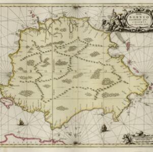
Insula Borneo et occidentalis pars Celebis cum adjacentibus insulis
c.1680-1709
Indonesia
The orientation of this map is unusual, with north to the right, so the west coast of Borneo is at the top. Its cartouche is decorated with drawings of seafaring people, and the scale with cherubs playing with cartography tools such as callipers.

Paskaerte zynde t'Oosterdeel van Oost Indien, met alle de Eylanden daer ontrendt geleegen van C. Comorin tot aen Iapan
1666
Brunei, Cambodia, East Timor, Indonesia, Laos, Myanmar, Malaysia, Singapore, Philippines, Southeast Asia, Vietnam, Thailand
This map of Southeast Asia features a rhumbline network, a web of lines used to aid navigation. Coastal areas are detailed while interiors are mainly blank, and there are illustrations of sailing ships, reinforcing the maritime focus of this map.

India quae Orientalis dicitur, et insvlae adiacentes
1664
Brunei, Cambodia, East Timor, Indonesia, Laos, Malaysia, Myanmar, Philippines, Singapore, Southeast Asia, Thailand, Vietnam
French text on the reverse of this map describes the religion, languages, crops, trade etc. of Aracam and Pegu (Myanmar), Siam (Thailand), Cambaja (Cambodia). The map is dedicated to the Dutch merchant Christophoro Thisio.

Mar di India
1659
Brunei, Cambodia, East Timor, Indonesia, Laos, Malaysia, Myanmar, Philippines, Singapore, Southeast Asia, Thailand, Vietnam
This mid-17th century map of the Indian Ocean has a colourful cartouche illustrated with paintings of Asian merchants and warriors with bows and arrows. The scale is decorated with paintings of cherubs.
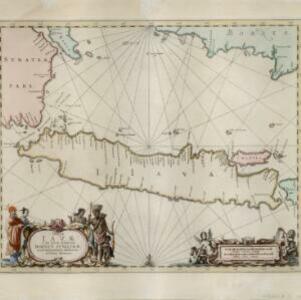
Insulæ Iavæ cum parte insularum Borneo Sumatræ, et circumjacentium insularum novissima delineatio
c.1657-1680
Indonesia
A map of the Java Sea between Java, Sumatra and Borneo. The web of lines is a rhumbline network, used to aid navigation. The cartouche and scale are decorated with paintings of Asian people and mythical creatures including cherubs.
- Compass Rose18
- Longitude and Latitude18
- [remove]Rhumbline Network18
- Scale17
- Written Note/Details7


