
Search Results
134 Results found


Plan de Salangor et de La Cote de Malaye: depuis la Pointe de Caran jusqu'au Mont Parcelar
1775
Malaysia
Map of the coast of Selangor on the west of the Malay Peninsula. The web of lines is a rhumbline network, the numbers indicate sea depth (bathymetry), and there are drawings of the side views of mountains (elevations), all to aid navigation.

Carte hydro-geo-graphique des Indes orientales, en deca̧ et au dela du Gange avec leur archipel
1771
Brunei, Cambodia, East Timor, Indonesia, Laos, Malaysia, Myanmar, Philippines, Singapore, Southeast Asia, Thailand, Vietnam
The arrows on this map show the direction of the seasonal monsoons of Southeast Asia during the late 18th century. Each arrow has a label in French, indicating the month. The hatched sea areas are where the winds always blow in the same direction.

A chart of the seas between the Straits of Banca and Po. Timon: with the eastern part of the Straits of Malacca
1767
Indonesia, Malaysia
This mid-18th century maritime map charts the seas between Peninsula Malaysia and Sumatra, including Singapore—named ‘Po. Panjang’—with the old and new Straits of Singapore marked. The numbers indicate sea depth (bathymetry).

Carte réduite des détroits de Malaca, Sincapour, et du Gouverneur
1755
Malaysia, Singapore, Indonesia
Maps like this aided navigation through the islands, shoals and reefs of Singapore and the Malacca Strait. Three routes around Singapore are shown, numbers on the sea indicate water depth, and the profile views of mountains were used as landmarks.
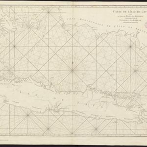
Carte de l'Isle de Java, avec les isles de Banca, de Billiton, et une partie de celles de Sumatra et de Borneo
c.1750
Indonesia
This 18th century maritime navigation map charts the waters between the islands of Java, Sumatra and Borneo. A route south towards the Sunda Strait, as taken by the French ship Mascarin in March and April 1772, is highlighted.

[De kust van Vietnam van Da Nang tot de monding van de Mekong]
1750
Vietnam
Map of the coast of Tsiompa and Couchinchina (Vietnam) designed for navigation, with a rhumbline network and bathymetry (sea depth). The large area marked with crosses represents the Paracel Islands. The modern city of Da Nang is at the far right.

De Straat Sunda in de Oost-Indische Zee tussen de Eylanden Sumatra en Java
c.1750
Indonesia
Chart of the Sunda Strait, focusing on bays and islands, and showing bathymetry (sea depth), anchor points, shoals and reefs, landmarks, and a rhumbline network, all to aid navigation. Includes an inset map of the bay of the city of Banten on Java.

Carte des Indes Orientalis
1748
Brunei, Cambodia, East Timor, Indonesia, Laos, Malaysia, Myanmar, Philippines, Singapore, Southeast Asia, Vietnam, Thailand
This mid-18th century map features labels noting the local populations, including the Kemois of the mountains and deserts of Cochinchinae (Vietnam) and the Byayos of Borneo. The map’s cartouche is embellished with maritime and military paraphernalia.
- Filter from 1595 to 1824
- [remove]Rhumbline Network134
- Longitude and Latitude124
- Compass Rose120
- Scale89
- Written Note/Details33
- Contour Lines/Elevation5


