
Search Results
134 Results found

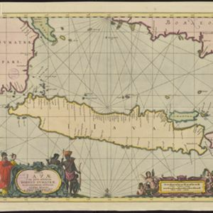
Insulæ Iavæ cum parte insularum Borneo Sumatræ, et circumjacentium insularum novissima delineatio
c.1700
Indonesia
A map of the Java Sea between Java, Sumatra and Borneo. The web of lines is a rhumbline network, used to aid navigation. The cartouche and scale are decorated with paintings of Asian people and mythical creatures including cherubs.
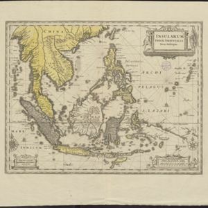
Insularum Indiæ orientalis nova descriptio
c.1700
Brunei, Cambodia, East Timor, Indonesia, Laos, Malaysia, Myanmar, Philippines, Singapore, Southeast Asia, Thailand, Vietnam
The outline of the island of New Guinea is very vague on this early 17th century map of Southeast Asia. The cartouche is decorated with two figures of Asian warriors: one holds a spear, the other a sword. There are also drawings of mermaids.


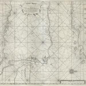
[Portolan chart of the South China Sea]
1701
Brunei, Cambodia, Indonesia, Laos, Malaysia, Philippines, Thailand, Vietnam
Hand-drawn portolan (nautical) chart, featuring a rhumbline network (the web of interconnected lines), bathymetry (sea depth), shoals and reefs, names of coastal settlements, and an elevation (side view) of a mountain at the north tip of Borneo.

Insulae Iavae pars Occidentalis
c.1710-1719
Indonesia
A map of Java with mountains, jungles, animals and crops. Bathymetry (sea depth) is marked, including on an inset map of Batavia harbour. Illustrations include Batavia Castle, and a lion—representing Belgium—receiving tribute and enslaving locals.

A chart of the eastermost part of the East Indies and China, from Cape Comarine to Iapan, with all the adjacent islands
1711
Brunei, Cambodia, East Timor, Indonesia, Laos, Malaysia, Myanmar, Philippines, Singapore, Southeast Asia, Thailand, Vietnam
An early 18th century navigation map, with a rhumbline network and a scale in English, French, Spanish and Dutch measurements. The cartouche includes a drawing of Asian people as primitive natives, as they were often seen in the West at the time.
A large draught of the east end of Java and Madura shewing the Streights of Bally
1711
Indonesia
This early 18th century maritime map charts the waters between the islands of Java, Madura and Bally (Bali). The web of lines is a rhumbline network, while the numbers indicate sea depth (bathymetry), both used to aid navigation.

A new and correct chart of part of the island of Java from the west end to Batavia with the Streights of Sunda
1711
Indonesia
This early 18th century maritime map charts the waters of the Straits of Sunda, between the islands of Java and Sumatra. The web of lines is a rhumbline network, while the numbers indicate sea depth (bathymetry), both used to aid navigation.

Orientaliora Indiarum Orientalium cum insulis adjacentibus à promontorio C. Comorin ad Iapan = Pascaert van t'Ooster gedeelte van Oost Indien van C. Comorin tot Iapan
1715
Brunei, Cambodia, East Timor, Indonesia, Laos, Malaysia, Myanmar, Philippines, Singapore, Southeast Asia, Thailand, Vietnam
The cartouche on this early 18th century navigation map features the title in Latin and Dutch, as well as a wealth of detailed drawings illustrating the region’s trade: Asian merchants, their goods and animals, and two female European customers.
- Filter from 1595 to 1824
- [remove]Rhumbline Network134
- Longitude and Latitude124
- Compass Rose120
- Scale89
- Written Note/Details33
- Contour Lines/Elevation5


