
Search Results
30 Results found


Map of Asia: Printed for the New York Central's 'Four-Track Series'
1900
Malaysia, Indonesia, Thailand, Myanmar, Cambodia, Vietnam, Papua New Guinea, Philippines, Singapore, Brunei, Laos, Southeast Asia
Colonial territory is labelled and colour-coded on this map of Southeast Asia. A list on the left edge gives the colonial status, size and population of Asian countries, and ranks the main cities by population. Gold and iron mines are marked.


China
1898
Brunei, Cambodia, East Timor, Indonesia, Laos, Malaysia, Myanmar, Philippines, Singapore, Southeast Asia, Thailand, Vietnam
This map highlights the colonisation of Southeast Asia, showing French Indochina (green), British Burma and Malaya (orange), the Dutch East Indies (pink), and the Spanish Philippines (green). In the region, only Siam (yellow) is independent.

Parts of Burma, Siam and the Shan States
1886
Myanmar, Thailand
This map charts the journey of Holt S. Hallett as he searched for a suitable route for a railway to transport British goods from Burma to Thailand and China. He wrote the book ‘A Thousand Miles on an Elephant in the Shan States’ about his expedition.

Map of South-Eastern Asia and Northern Australia: showing the districts in Annam and Tonquin which France proposes to annex and to place under a Protectorate, the portion of New Guinea proposed to be acquired by Queensland, and the districts affected by the volcanic eruptions in Java
1883
Southeast Asia, Singapore, Thailand, East Timor, Vietnam, Brunei, Cambodia, Indonesia, Laos, Malaysia, Myanmar, Papua New Guinea, Philippines
This 1883 map shows European colonial territories in Southeast Asia. An inset map details the proposed French annexation of Tonquin, Annam and Cochin China (modern Vietnam). International telegraph lines are also marked.
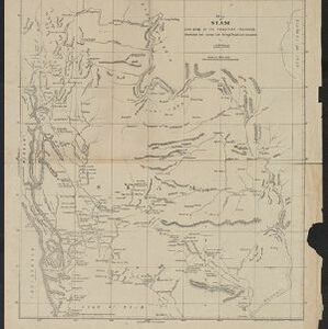
Map of Siam and some of its tributary provinces
1870
Cambodia, Laos, Myanmar, Thailand
A map of Siam (Thailand) and parts of Burma (Myanmar), Cambodia and Laos, focusing on the river networks, and the mountain ranges which are represented by hachures: short lines/dashes that give a sense of the shape and steepness of terrain.

The Island of Ceylon / Burmah, Siam and Anam
1870
Myanmar, Laos, Cambodia, Thailand, Vietnam, Malaysia
This map of mainland Southeast Asia has colour-coded borders: Burmah (Myanmar) in red, Siam (Thailand) in brown, and Anam (Vietnam) in green. The British territory of Penang is also bordered in red. Independent areas are bordered in grey.

Western part of the Java Sea : from Lucipara I. to Sunda Strait and Batavia
1866
Indonesia
Designed to aid navigation around the western Java Sea, this map features bathymetry (sea depth), current and tide data, and is marked with shoals, reefs and other hazards. Written notes add details at specific locations (e.g. ‘heavy tide rips’).
- [remove]Longitude and Latitude30
- [remove]Scale30
- Contour Lines/Elevation12
- Written Note/Details9
- Compass Rose8
- Rhumbline Network3


