A new plan of the Straits, situated to the east of Java & Madura commonly called the Straits of Bali and of Pondi and Respondi
event1794
location_onIndonesia
A chart of the seas between the Straits of Banca and Po. Timon: with the eastern part of the Straits of Malacca
event1767
location_onIndonesia, Malaysia
Carte des Indes Orientales
event1748
location_onBrunei, Cambodia, East Timor, Indonesia, Laos, Malaysia, Myanmar, Philippines, Singapore, Southeast Asia, Thailand, Vietnam
Particular-see-charte der Strass Sunda, nebst denen darinnen befindlichen insulen und sandbäncken
event1744
location_onIndonesia
Molvccae insvlae celeberrimae
eventc.1730-1778
location_onIndonesia
Insulae Iavae pars Occidentalis
event1728
location_onIndonesia
De landvoogdy van Amboina met de elf onderhoorige eylanden
event1726
location_onIndonesia
Orientaliora Indiarum Orientalium cum insulis adjacentibus à promontorio C. Comorin ad Iapan = Pascaert van t'Ooster gedeelte van Oost Indien van C. Comorin tot Iapan
event1715
location_onBrunei, Cambodia, East Timor, Indonesia, Laos, Malaysia, Myanmar, Philippines, Singapore, Southeast Asia, Thailand, Vietnam
A chart of the eastermost part of the East Indies and China, from Cape Comarine to Iapan, with all the adjacent islands
event1711
location_onBrunei, Cambodia, East Timor, Indonesia, Laos, Malaysia, Myanmar, Philippines, Singapore, Southeast Asia, Thailand, Vietnam
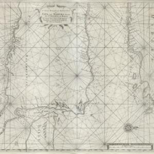
A new and correct chart of part of the island of Java from the west end to Batavia with the Streights of Sunda
event1711
location_onIndonesia
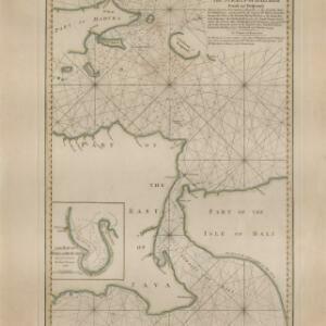
A large draught of the east end of Java and Madura shewing the Streights of Bally
event1711
location_onIndonesia
Indiae orientalis, nec non insularum adiacentium
event1698
location_onMyanmar, Philippines, Singapore, Southeast Asia, Thailand, Vietnam, Malaysia, Laos, Indonesia, East Timor, Cambodia, Brunei