
Search Results


Map to illustrate the Siamese question: showing the present limits of French claims, and the additional territory now demanded
1893
Cambodia, Laos, Malaysia, Myanmar, Thailand, Vietnam
Map highlighting areas of eastern Siam (Thailand) claimed by France. Notes describe Siam’s geography, government, population, military and trade (rice, teak, pepper, bullocks, fish, hides, tin, cardamom, tin), including trading partners by tonnage.

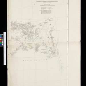
No. 4 preliminary chart of the principal triangulation of the Mandalay meridional series
1893
Myanmar
A triangulation map of part of Upper Burma (Myanmar), showing nine locations (‘hill stations’) joined with straight lines to create a triangulation network. Each hill station’s latitude and longitude, height above sea level, and description is given.


British Burma, Pegu division: With additions to railways up to 1891
1891
Myanmar
Topographical map of the Pegu Division of British Burma (Myanmar), spread over four sheets. In addition to mountains, forests, rivers and wetlands, rice fields, routes (road, railway, path, telegraph), villages and pagodas are marked.
- Filter from 1535 to 1900
- [remove]Myanmar123
- Thailand105
- Malaysia90
- Laos88
- Vietnam88
- Cambodia87
- Indonesia84
- Singapore82
- Brunei77
- Philippines76
- Southeast Asia74
- East Timor71
- more Simple Location »
- [remove]Scale123
- [remove]Written Note/Details123
- Longitude and Latitude118
- Compass Rose40
- Contour Lines/Elevation36
- Rhumbline Network12


