
Search Results
15 Results found


Carte des environs de Batavia = Kaart van de buitenstreeken van Batavia
c.1772-1780
Indonesia
This late 18th century map of Batavia (Jakarta) focusses on the network of canals and rivers surrounding the city, as well as the many fields and plantations, including rice fields (‘Champ de Ris’) and sugarcane (‘Cannes de Sucre’).


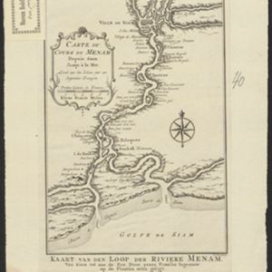
Carte de l'Inde au-delà du Gange comprenant les Royaumes de Siam, de Tunquin, Pegu, Ava, Aracan &c.
c.1757
Cambodia, Laos, Malaysia, Myanmar, Thailand, Vietnam
The kingdoms of mid-18th century mainland Southeast Asia are shown on this map: Ava and Pegu (Myanmar), Siam (Thailand), Tonquin and Cochinchine (Vietnam), Camboie (Cambodia) and Laos. Rivers are also prominent, and mountains are shown pictorially.

Carte des Royaumes de Siam, de Tunquin, Pegu, Ava, Aracan &c.
c.1755
Cambodia, Laos, Malaysia, Myanmar, Thailand, Vietnam
The kingdoms of mid-18th century mainland Southeast Asia are shown on this map: Ava and Pegu (Myanmar), Siam (Thailand), Tonquin and Cochinchine (Vietnam), Camboie (Cambodia) and Laos. The text is in French, with the title also in Dutch at the base.

Carte du Cours de la Riviere de Tunquin: depuis Cacho jusqu'à La Mer
1755
Vietnam
Map of the Tunquin River (Red or Hong River) from the city of Cacho (Hanoi, Thailand) to its mouth. At the mouth, bathymetry (sea depth), shoals and anchor points are marked. A place named Hean is labelled as an English and French trading post.

Plan de la ville et forteresse de Malaca = Grondtekening van de Stad en Vesting Malakka
1750
Malaysia
This mid-18th century plan of the city of Malaca (Malacca/Melaka) focuses on the military fort (‘A Famosa [The Famous]’), but also includes two churches, a mosque and a Chinese temple. Two markets are also marked, as is the entrance to the port.
- Filter from 1746 to 1772
- [remove]Bellin, Jacques Nicolas15
- [remove]Schley, Jacobus van der15
- Prévost, Abbé3
- Du Bois, J.P.J.1


