
Search Results
93 Results found


Kaart der residentie Zuider- en Ooster-afdeeling van Borneo
1899
Indonesia
On this map, the residency of South and East Borneo is divided into departments (green borders) and provinces (yellow borders). There is an inset plan of the city of Banjarmasin, with rivers, buildings, residential areas, roads and crops marked.


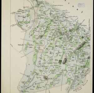
Kaart van het gebied bezet in Groot-Atjèh
1898
Indonesia
A six-sheet map of Groot-Atjèh (Aceh, northern Sumatra) focusing on areas occupied during the Aceh War (1873–1904) between the Sultanate of Aceh and Dutch colonists. It shows military positions and fortifications, buildings, routes and crops.

Schetskaart van het Toba-meer en aangrenzende landstreken
1898
Indonesia
Map of Lake Toba and the surrounding area in northern Sumatra, featuring mountains, forests, types of terrain (undergrowth, field, grass), rivers, roads and settlements. There is an inset map that shows the other maps referenced in producing the map.

Kaart de residentie Wester-afdeeling van Borneo
1898
Indonesia
Topographical map of western Borneo, with inset maps of the islands off the west coast, and of the city of Pontianak including the docks and crops grown near the city (rice, coconut, mangosteen, sago, alang-alang, indigo plant, sugarcane, bamboo).


Map of the Island of Singapore and its dependencies
1898
Singapore
Map of Singapore Island, divided into Districts, including the surrounding islands and straits. The city centre, roads and forests are marked. MacRitchie Reservoir is at the centre of the island, with coconut plantations along the east coast.


Kaart van het gebied bezet in Groot-Atjeh, met de nederzettingen Lepoeng en Lehoeng
1897
Indonesia
A map of Groot-Atjeh, Lepoeng and Lehoeng, at the northern tip of Sumatra, detailing routes (rivers, roads, railways), crops (rice, banana, sugarcane, betel, pepper, alang-alang, bamboo) and land features (forests, mountains, wetlands).

Expeditiën naar Bali in 1846, -48, -49 en -68
1897
Indonesia
Map of Bali, with five inset maps showing locations of Dutch military interventions on the island from 1846 to 1868. Troop positions and Balinese defences—barricades, moats—are marked, along with terrain, roads, palaces, temples and villages.
- [remove]Path93
- [remove]Road93
- River87
- Postal Route52
- Railway/Tramway37
- Canal17
- Bridge13
- Telegraph/Telephone11
- [remove]Mountain/Volcano93
- Wetlands73
- Jungle/Wooded Area68
- Mangrove5
- Wild Animals1


