Search

Search Results

Malay Archipelago, or East India Islands

event1851

location_onBrunei, Cambodia, East Timor, Indonesia, Laos, Malaysia, Myanmar, Papua New Guinea, Philippines, Singapore, Southeast Asia, Thailand, Vietnam

This mid-19th century map of Southeast Asia is illustrated with drawings of indigenous people from New Guinea, a ‘bee bear’ (probably a sun bear), a sailboat in front of Victoria Mount in New Guinea, and a village and palm trees in Sarawak, Borneo.

The continent and islands of Asia: with all the latest discoveries

event1839

location_onBrunei, Cambodia, East Timor, Indonesia, Laos, Malaysia, Myanmar, Papua New Guinea, Singapore, Philippines, Southeast Asia, Thailand, Vietnam

On this map of Asia, the South China Sea is labelled ‘Malayan Sea’. Small islands, shoals and reefs are shown. A label in Cochin China (Vietnam) reads ‘mountains inhabited by the uncivilized people called Kemoys’.

The continent and islands of Asia: with all the latest discoveries

event1809

location_onVietnam, Myanmar, Papua New Guinea, Philippines, Singapore, Southeast Asia, Thailand, Malaysia, Laos, Indonesia, East Timor, Cambodia, Brunei

Southeast Asia is on the last sheet of this map of Asia. The South China Sea is labelled ‘Malayan Sea’. Small islands, shoals and reefs are shown. A label in Cochin China (Vietnam) reads ‘mountains inhabited by the uncivilized people called Kemoys’.

East Indies

eventc.1800-1899

location_onBrunei, Cambodia, East Timor, Indonesia, Laos, Malaysia, Myanmar, Philippines, Singapore, Southeast Asia, Thailand, Vietnam

Longitude is indicated in two different ways on this mid-18th century map: along the top border, it is shown in degrees (number of degrees east of London); more unusually, along the bottom border, it is shown in time (number of hours east of London).

East Indies

event1769

location_onBrunei, Cambodia, East Timor, Indonesia, Laos, Malaysia, Myanmar, Philippines, Singapore, Southeast Asia, Thailand, Vietnam

Longitude is indicated in two different ways on this mid-18th century map: along the top border, it is shown in degrees (number of degrees east of London); more unusually, along the bottom border, it is shown in time (number of hours east of London).

Asia: corrected from the observations communicated to the Royal Society at London and the Royal Academy at Paris

event1725

location_onBrunei, Cambodia, East Timor, Indonesia, Laos, Malaysia, Myanmar, Philippines, Singapore, Southeast Asia, Thailand, Vietnam

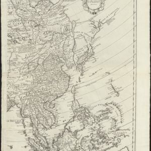
An early 18th century map of Asia by the English cartographer John Senex, featuring labels noting details of the inhabitants of some areas e.g. on Borneo: ‘The Middle of this Isle is Inhabited by a People call’d Beaujous Idolaters’.

A map of the East-Indies and the adjacent countries: with the settlements, factories and territories, explaning what belongs to England, Spain, France, Holland, Denmark, Portugal &c.

eventc.1720

location_onBrunei, Cambodia, East Timor, Indonesia, Laos, Malaysia, Myanmar, Philippines, Singapore, Southeast Asia, Thailand, Vietnam

This map showcases the colonial territories of Southeast Asia in the 18th century, with text detailing trading information and the products of each region. There are five inset maps featuring plans of specific trading ports.

A map of the East-Indies and the adjacent countries: with the settlements, factories and territories, explaning what belongs to England, Spain, France, Holland, Denmark, Portugal &c.

event1720

location_onBrunei, Cambodia, East Timor, Indonesia, Laos, Malaysia, Myanmar, Philippines, Vietnam, Thailand, Southeast Asia, Singapore

This map showcases the colonial territories of Southeast Asia in the 18th century, with text detailing trading information and the products of each region. There are five inset maps featuring plans of specific trading ports.

A map of the East-Indies and the adjacent countries: with the settlements, factories and territories, explaining what belongs to England, Spain, France, Holland, Denmark, Portugal &c.

event1717

location_onBrunei, Cambodia, East Timor, Indonesia, Laos, Malaysia, Myanmar, Philippines, Singapore, Southeast Asia, Thailand, Vietnam

This map showcases the colonial territories of Southeast Asia in the 18th century, with text detailing trading information and the products of each region. There are five inset maps featuring plans of specific trading ports.

Asia corrected from the observation communicated to the Royal Society at London and the Royal Academy at Paris

eventc.1714

location_onBrunei, Cambodia, East Timor, Indonesia, Laos, Malaysia, Myanmar, Philippines, Singapore, Southeast Asia, Thailand, Vietnam

This early 18th century map of Asia features a drawing of a woman burning offerings on an altar, while two children carry cornucopias, and a camel looks on. The Roman god Mercury descends from the sky in the background wearing his winged helmet.

close